De Department of Conservation oftewel DOC heeft de wandelroutes in Nieuw-Zeeland onder verdeelt in verschillende gradaties:
- Easy access short walk
- Short Walk
- Walking Track
- Great Walk – Easier Tramping Track
- Tramping Track
- Route
De walks zijn voor iederen goed te lopen. Ook zonder enige wandelervaring. Wandelschoenen aan en gaan. De tramping tracks zijn langere uitdagendere routes. De great walks zijn goed onderhouden en geschikt voor iedereen met enige wandelervaning. Op tramping tracks is meer ervaring vereist en de nodige zelfredzaamheid als het goed om overnachten, eten en overleven. Routes zijn groteendeels ongemarkerde tochten voor de ervaring wandelaar op zoek naar avontuur.
Te Araroa Trail
De Te Araroa Trail, die heel Nieuw-Zeeland doorkruist, over de Noord- als de Zuid-eilanden, strekt zich uit van Cape Regina, waar de Stille Oceaan de Tasmanzee ontmoet, en slingert zuidwaarts naar Bluff, eindigend op de zuidpunt van het Zuidereiland. De 3000 kilometer lange route omvat een adembenemende mengelmoes van de meest spectaculaire natuurlijke wonderen van het land, waaronder de Northland Forests, de door zee overstroomde valleien van de Marlborough Sounds, de Zuidelijke Alpen en uiteraard locaties die beroemd zijn gemaakt door de Lord of the Rings filmtrilogie, inclusief Togariro National Park. Hoewel je op stukken van de route niet aan zelfvoorzienend kamperen ontkomt, zijn er verschillende accommodatiemogelijkheden verspreid langs de route die comfort bieden aan wandelaars, waaronder vakantieparken, pensions en hutten in het achterland die worden beheerd door het Department of Conservation van Nieuw-Zeeland.
Onderstaande route is een vereenvoudigde versie van de GPX tracks die op de site van de route te vinden zijn.
Queen Charlotte
De Queen Charlotte Track is een 71 km lange wandelroute tussen Queen Charlotte Sound en Kenepuru Sound in de Marlborough Sounds op het Zuidereiland. Het strekt zich uit van Ship Cove in het noorden tot Anakiwa in het zuiden. Voor de meeste delen leidt het pad door bossages met inheemse planten over de heuvelrug tussen de sounds, met aan beide kanten een goed uitzicht.
De wandelroute is ook opengesteld voor fietsers en geschikt voor mountainbikes.
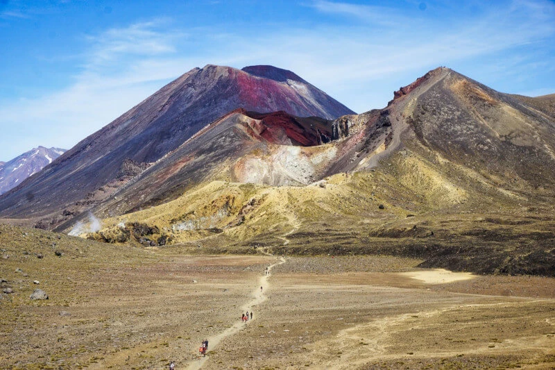
Milford Track
De Milford Track is een route van ruim 50 kilometer naar de prachtige Milford Sound – een van de vele fjorden in Fiordland National Park. De route wordt beschouwd als een gemiddeld zware wandeling, hoewel het tot 4 dagen duurt om te voltooien. Gedurende het hele avontuur kom je langs prachtige uitzichten op meren, watervallen, torenhoge bergtoppen, bossen die er magisch uitzien en aanvoelen, en uiteindelijk een ongelooflijk uitzicht op de fjord. Het is een ervaring van je leven. De route is niet voor niets een van de great walks van Nieuw Zeeland
-
northern section of Te Araroa. Van: Cape Reinga Lighthouse. Naar: Shorland Park, Island Bay, Wellington. Lengte: 1689 Kilometer.
-
Sand facing the Tasman Sea, dense bush (forests), steep hills and fast-rising rivers contrast with towns facing the Pacific Ocean. Challenges: cross tidal estuaries - choices - wait for low tide, pack float, appeal to a friendly boatie or find a bypass.. Van: Cape Reinga lighthouse. Naar: Mangawhai Heads. Lengte: 439 km.
- Cape Reinga (northern start/end) is accessible by road from Kaitaia. Kerikeri on east coast is an alternative start/end.. Van: Cape Reinga lighthouse. Naar: Ahipara. Lengte: 100,5 km.
- NORTHLAND FORESTS The western forest, Herekino, also known as Orowhana, has a rahui (closure notice) because of Kauri die back disease. Detour through Kaitaia, Ruaroa and Takahue Roads to rejoin the trail at Takahue. Van: Ahipara. Naar: Puketi Recreation Centre. Lengte: 98 km.
- CLOSURES: Lambing (April 29 - September 14) (five months) Last weekend in February Occasional summer closures for clay mining ALTERNATIVE: Puketotara Road.. Van: Puketi campsite. Naar: Kerikeri - Stone Store and Kemp House. Lengte: 24 km.
- Te Araroa’s inaugural plaque revealed on 7 February 1995: a local volcanic stone embedded with lines from A R D Fairburn’s poem ‘To a Friend in the Wilderness’ I could be happy, in blue and fortunate weather, Roaming the country between you and the sun.. Van: Kerikeri - Kemp House and Stone Store. Naar: Waitangi Bridge, Paihia. Lengte: 21 km.
- Van: Waitangi Bridge. Naar: Opua ferry wharf. Lengte: 8 km.
- Lengte: 22 km.
- PARTS OF RUSSELL FOREST ARE AFFECTED BY KAURI DIEBACK DISEASE. PLEASE FOLLOW INSTRUCTIONS TO WASH BOOTS ON WAY IN AND WAY OUT OF FOREST. posted May 2019. Van: Opua ferry wharf. Naar: Whangarei Heads. Lengte: 137 km.
- Tide information: Check the best times for walking on www.niwa.co.nz/our-services/online-services/tides. Van: Whangarei Heads (south side). Naar: Bream Bay. Lengte: 27 km.
- Cullen Road: Forestry traffic operates Mon-Sat 05h-16h Felling can occur near the road Please observe signage and traffic management instructions We recommend you wear hi-viz vest and/or pack covers. Van: Cove and Cullen Road. Naar: Bream Tail Raod. Lengte: 14 km.
- Tide information: Check the best times for walking on www.niwa.co.nz/our-services/online-services/tides. Van: Cove and Bream Tail Roads. Naar: Mangawhai Heads. Lengte: 8 km.
-
The trail soon goes semi-rural before returning to the coast with suburban footpaths and a ferry over the Waitemata to the CBD. Then crosses the isthmus to the Manukau before experiencing more of the diversity of the Auckland region.. Van: Manghawhai Heads. Naar: Mercer. Lengte: 208 km.
- Van: Mngawhai Heads, Wintle Street. Naar: Pakiri Beach access. Lengte: 30 km.
- Van: Pakiri Beach holiday camp. Naar: cnr Govan Wilson and Matakana Valley Rds. Lengte: 11 km.
- Lengte: 38 km.
- Van: Remimiger and Ahuroa Roads. Naar: Puhoi township. Lengte: 5 km.
- The kayak route is open for 10 months (September to June) and is best down on an outgoing tide. At any time of the year you can walk to Wenderholm or close by Waiwera using the left fork (right coming north). Van: Puhoi township. Naar: Wenderholm Kayak. Lengte: 7 km.
- Van: Wenderholm Regional Park. Naar: Stillwater. Lengte: 24,5.
- Okura Bush Walkway has a Rahui imposed on 10 May 2018 and reviewed and renewed on 12 Apr 2019. Continue on East Coast Road or ford at low tide. See alternative route for this.. Van: Sour Road near Stillwater. Naar: Long Bay.
- Van: Long Bay. Naar: Devonport. Lengte: 24 km.
- Auckland has long been known as Tamaki Makaurau - the spouse desired by a hundred lovers." All who saw it for its fertile volcanic slopes sheltered fishing sites and access to the greatest waterway in New Zealand, the Waikato River, desired it.". Van: Ferry Terminal, Quay Street (bottom of Queen Street), Auckland CBD. Naar: Onehunga. Lengte: 15 km.
- Cross the footbridge to Mangere foreshore and skirt around Auckland International Airport.. Lengte: 25 km.
- Van: Prices Road, Puhinui. Naar: Totara Park, Wairere Road, Manurewa. Lengte: 10 km.
- Mainly urban roads to beyond Papakura. After than mainly open country with a hill to climb. This route follows the maps issued November 2018. An earlier route through the Hunua Ranges is now avoided as a result of Kauri die-back disease.. Van: Totara Park, Wairere Road, Manurewa. Naar: Bombay. Lengte: 25 km.
- a route that avoids both SH1 and SH2 (except to cross over). Van: Bombay. Naar: Mercer. Lengte: 18 Kilometer.
- a route from Mangatawhiri to Mercer. Van: Mangatawhiri. Naar: Mercer. Lengte: 14 Kilometer.
-
The Waikato was a source of life for Māori. We follow Waikato for 80 km to Hamilton (including Hakarimata ridge) and then the Waipa for 160 km to Pureora, diverting to ascend Pirongia (dominant on the skyline) and pass the spectacular Waitomo Caves.. Van: Mercer. Naar: Pureora. Lengte: 248 Kilometer.
- Lengte: 25 km.
- Walkers are offered protection of the taniwha Tarakokomako. And told the names the seven now-vanished ancestral villages and the two existing marae en route. The plaque carved with a taniwha has a greeting from Tainui, the people of Waikato.. Van: Rangiririri. Naar: Huntly. Lengte: 21,5.
- The Hakarimata Track is steep, hilly and arduous but the bush and views are worth it.. Van: Huntly. Naar: Ngaruawahia. Lengte: 12 km.
- Ngaruawahia is the home of the Maori King and the magnificent Turangawaewae Marae. At Ngaruawahia two great rivers merge - Waikato and Waipa. These were important canoe routes and later served settlers.. Van: Waingaro Bridge, Ngaruawahia. Naar: Pukete Road, Hamilton. Lengte: 12 Kilometer.
- Hamilton's Taitua Arboretum is a collection of mature trees on 20 hectares of open pasture, lakes and woodland gardens linked by a network of walking tracks and bridges and features great views and wonderful bird life. Open 7 days from 8am to before dusk.. Van: Pukete Road, Hamilton. Naar: Taitua Arboretum, Taitua Road, Hamilton. Lengte: 18 km.
- Footpaths, back road & SH road margins, pasture & river esplanade. HAZARDS: Vehicles Farm operations - please give way to farm animals; Bypass Waipa River Banks when in flood Respect private land NO dogs Kapamahunga path closed 1 Aug-10 Nov - lambing. Van: Taitua Arboretum, Taitua Road, Hamilton. Naar: DOC picnic area, Limeworks Loop Rd. Lengte: 28 km.
- Pirongia Weather conditions can change rapidly, especially at higher altitudes. Carry a change of clothing, wet weather gear and sufficient food to cater for any emergency.. Van: Kaniwhaniwha Reserve, 573 Limeworks Loop Rd. Naar: junction with Pirongia West Road. Lengte: 16,5.
- Closed annually 1 Aug - 1 Oct for lambing. Van: Pirongia Road West. Naar: Waitomo Walkway carpark, Waitomo Village. Lengte: 43,5.
- Medium-grade tramp - farms and bush and a small portion of road margin. 150-metre ascents. Pause on high karsts to view King Country's low agriculture and tumbled limestone that rise to volcanic summits – north > Pirongia, east > Pureora, south > Ruapehu. Van: Waitomo Village. Naar: Shearing monument, Rora Street, Te Kuiti. Lengte: 17,5.
- Van: Shearing monument, Rora Street, Te Kuiti. Naar: Barryville Road, Pureora Forest. Lengte: 56 km.
-
From the mountains to the sea Over tussock, through bush and down a grand river, exposed to nature and, potentially, all its elements. Two National Parks to savour - Tongariro and Whanganui. Both are dramatic and spiritual places.. Van: Ketetahi Shelter, Tongariro. Naar: Gladstone Road and Poads Road, Levin. Lengte: 320 km.
- Van: Pureora Forest Park, Barryville Rd. Naar: Hakiaha St (SH4), Taumarunui. Lengte: 110 Kilometer.
- Van: Taumarunui. Naar: Ketetahi Shelter, near SH46. Lengte: 72 Kilometer.
- Van: Ketetahi Shelter. Naar: Mangatepopo Track Turnoff. Lengte: 17,5.
- Van: Mangatepopo Track turnoff, Tongariro National Park. Naar: Railway Station, National Park. Lengte: 30 km.
- There are no facilities of any type at the Kurua-Retaruke Rd end of this track. Trampers need to be totally independent and make their own pre-arrangements for food, shelter or pick-ups.. Van: Railway Station, National Park. Naar: Mangapurua Landing, Whanganui River. Lengte: 89 km.
- River transport is the only option from Mangapurua Landing to Pipiriki. Pre-book delivery of kayaks or canoes. Hazards: Capsize: limited places to exit onto bank Cycling: keep to the left and single file. Walking: narrow, winding, short sight lines ahead. Van: Mangapurua Landing, Whanganui River. Naar: Wanganui Motor Boat Club ramp, Anzac Parade, Wanganui. Lengte: 119 km.
- Hazards Vehicles - take much care on SH3, and heading into Bulls Farming operations Forestry operations Track exposed to sun, wind or cold Few water sources. Van: Wanganui Motor Boat Club ramp, Anzac Parade, Wanganui. Naar: Junction of SH1 (High St and SH3, Bulls. Lengte: 58,5.
- Road margins all the way. Shoulders often minimal. Face the oncoming traffic (you on right side in Aotearoa-New Zealand), EXCEPT where: a) view ahead is restricted - drivers of you b) there is a footpath on the other side. Van: Bulls. Naar: Feilding. Lengte: 21 km.
- Road margins much of the way. Shoulders often minimal. Face the oncoming traffic (you on right side in Aotearoa-New Zealand), EXCEPT where: a) view ahead is restricted - drivers of you b) there is a footpath on the other side. Van: Feilding. Naar: Palmerston North - Riverside Drive. Lengte: 17,5.
- Road margins much of the way. Shoulders often minimal. Face the oncoming traffic (you on right side in Aotearoa-New Zealand), EXCEPT where: a) view ahead is restricted - drivers of you b) there is a footpath on the other side. Van: Palmerston North - Napier Road. Naar: Old West Road at Turitea. Lengte: 13 km.
- Old West Road (SH57), Palmerston North to junction of Gladstone Road and Poads Road, Levin. Many short but steep (>10%) ascents and descents. Several streams to pass through.. Van: Old West Road, Turitea. Naar: Poads Road on the outskirts of Levin. Lengte: 60 km.
-
Lengte: 163 Kilometer.
-
Sand facing the Tasman Sea, dense bush (forests), steep hills and fast-rising rivers contrast with towns facing the Pacific Ocean. Challenges: cross tidal estuaries - choices - wait for low tide, pack float, appeal to a friendly boatie or find a bypass.. Van: Cape Reinga lighthouse. Naar: Mangawhai Heads. Lengte: 439 km.
-
Van: Ship Cove, Totāranui / Queen Charlotte Sound. Naar: Stirling Point, Bluff (South Pole - 5,000 km away - might be visible on a clear day).
-
Van: Ship Cove, Totāranui / Queen Charlotte Sound. Naar: Rocks Hut, Pelorus River.
- Van: Ship Cove. Naar: Anakiwa.
- Van: Anakiwa. Naar: Pelorus Bridge.
- Van: Pelorus Bridge. Naar: Hacket Hut.
-
Van: Ship Cove, Totāranui / Queen Charlotte Sound. Naar: Boyle Village, Lewis Pass Road (SH7).
-
Van: Boyle Village, Lewis Pass Road (SH7). Naar: Birchwood Road, South Canterbury.
- Van: Birchwood Road, South Canterbury. Naar: Mavora Lakes Road, Southland.
- Van: Mavora Lakes Road, Southland. Naar: Stirling Point, Bluff (South Pole - 5,000 km away - might be visible on a clear day).
-
Van: Ship Cove, Totāranui / Queen Charlotte Sound. Naar: Rocks Hut, Pelorus River.
- Lengte: 48 Kilometer.
- Lengte: 7,5.
- path nr.44 from Rother Wanderführer, Neuseeland. Gids (Ook te koop bij: Amazon en De Zwerver)
- path nr.54 from Rother Wanderführer, Neuseeland.
- Route nummer 42 uit de Rother Wanderführer, Neuseeland.
-
01 Lake Waikaremoana
02 Tongariro Northern Circuit
03 Whanganui Journey
04 Abel Tasman Coast Track
05 Heaphy Track
06 Routeburn Track
07 Milford Track
08 Kepler Track
09 Rakiura Track.
- Lengte: 60 Kilometer.
- Lengte: 78,4 km.
- Lengte: 32 Kilometer.
- De 53 kilometer lange Milford Track is een van mooiste wandelingen ter wereld en begint aan de kop van Lake Te Anau, voordat hij zich een weg baant via valleien die zijn uitgehouwen door gletsjers, door gematigde regenwouden en langs watervallen. Deze wandeling laat echt het beste van Fiordland zien, een van de meest legendarische nationale parken van Nieuw-Zeeland.. Lengte: 54 Kilometer. Gids
- Route 48 uit de Rother Wanderführer, Neuseeland.
- Route nummer 52 uit de Rother Wanderführer, Neuseeland.
-
70 km of Marlborough Sounds.
- Private access only.
-
- Lengte: 3,1.
Bron en © OpenStreetMap & auteurs
Praktische tips Nieuw-Zeeland
Enkele praktische tips voor wandelen en fietsen in Nieuw-Zeeland
- Je uitrusting dient brandschoon te zijn voordat je naar Nieuw-Zeeland reist. Hierop wordt gecontroleerd bij de biosecurity bij aankomst op de luchthaven van Auckland. Denk aan je schoenzolen, fietsbanden, haringen, het grondzeil van je tent enzovoorts.
- Het invoeren van levensmiddelen is aan strenge regels onderworpen. Gevriesdroogd eten mag meestal wel. Je moet levensmiddelen altijd
- aangeven.
- De campings hebben allemaal een keuken en kookgerei, zolang je niet gaat wildkamperen kun je je kookspullen thuislaten.
- De afstanden zijn groot, zorg voor voldoende proviand en drinken. Neem eventueel een waterfilter mee.
- Goede regenkleding is zeer aan te raden.
- Wild kamperen is niet zomaar toegestaan
-
- About 6h for the full walkway. No bikes allowed..
- Volgens velen de mooiste eendaagse wandeling die je kunt maken of de flanken van de Tongariro vulkaan en langs de Ngauruhoe en Ruapehu. Er zijn diverse touroperators die het vervoer naar en van het start- en eindpunt regelen.. Lengte: 19,4.
- private walk at the coast of Kaikoura. Van: Ngaroma Farm. Naar: Ngaroma Farm.
- Lengte: 7 Kilometer.
- Lengte: 12 km.
- Lengte: 17,8km.
- Lengte: 16,5km.
- Lengte: 10km.
- Lengte: 1km.
- Lengte: 3,5km.
- Between 2016 and 2018 the 1.4 km section from Aotea Quay to Rangiora Avenue was significantly upgraded, including new surfaces and elimination of casual car parking.
- path nr.35 from Rother Wanderführer, Neuseeland.
- vaak in één adem genoemd wordt met de Tongariro Alpine Crossing als mooiste daghikes van Nieuw-Zeeland. Gids (Ook te koop bij: Amazon en De Zwerver)
- path nr.37 from Rother Wanderführer, Neuseeland.
- path nr.38 from Rother Wanderführer, Neuseeland.
- path nr.30 from Rother Wanderführer, Neuseeland.
- path nr.31 from Rother Wanderführer, Neuseeland.
- path nr.32 from Rother Wanderführer, Neuseeland.
- path nr.33 from Rother Wanderführer, Neuseeland.
- path nr.34 from Rother Wanderführer, Neuseeland.
- path nr.49 from Rother Wanderführer, Neuseeland.
- path nr.51 from Rother Wanderführer, Neuseeland.
- path nr.50 from Rother Wanderführer, Neuseeland.
- path nr.40 from Rother Wanderführer, Neuseeland.
- Collection of walks to explore Waiheke Island and discover its natural beauty. On Te Ara Hura walking track network you can explore the coastline, pass through native bush and visit historic sites. There's a range of walks, from short and easy through to.
- path nr.43 from Rother Wanderführer, Neuseeland.
- path nr.39 from Rother Wanderführer, Neuseeland.
- path nr.57 from Rother Wanderführer, Neuseeland.
- path nr.58 from Rother Wanderführer, Neuseeland.
- path nr.28 from Rother Wanderführer, Neuseeland.
- path nr.27 from Rother Wanderführer, Neuseeland.
- path nr.25 from Rother Wanderführer, Neuseeland.
- path nr.23 from Rother Wanderführer, Neuseeland.
- Van: Kennedy Bush Track.
- Van: Ahuriri Bush. Naar: Godley Heads.
- Northern Crossing links the Ōhau and Waingawa catchments in Tararua Forest Park - one of four classic tramps here - 3 to 5 days - expert route. Van: east of Levin. Naar: top of Waingawa Road, Masterton.
- 1 of 4 classics links Otaki and Tauherenikau catchments. Originally from Otaki Forks to Wairarapa Plains and now the Kaitoke Basin. It was popularised from the 1920s by the Tararua Tramping and other clubs in the Hutt Valley and Wairarapa..
- Lengte: 1 Uren.
- Loop: Wainui – Gibbs Hill – Totaranui.
- A 16km walk, taking at least 4 hours to complete.
- Van: Tilley Road, Paekakariki. Naar: US Marine Corps outdoor museum, MacKays Eentrance.
- Lengte: 9,44.
- Lengte: 7 Kilometer.
- Low tide alternative routes for Te Araroa.
- Hutt River Trail (HRT) runs from Petone Station along the beachfront to Hikoikoi Reserve and from there to Te Marua, Upper Hutt where it links into the Remutaka Rail Trail. There are many access points along Te Awa Kairangi / Hutt River.. Van: Petone Station, Lower Hutt. Naar: Plateau Road, Te Marua, Upper Hutt.
- Between 2016 and 2018 the 1.4 km section from Aotea Quay to Rangiora Avenue was significantly upgraded, including new surfaces and elimination of casual car parking.
- A shared path for runners, walkers and cyclists. A central section, from Tawa Station to Findlay Street mainly uses residential roads. The north and south sections, both of about 2 km each follow a purpose built dedicated way.. Lengte: 8 km.
- Through Seton Nossiter Park from Mark Avenue (between Granada and Paparangi) to Bushland Grove, Paparangi and Colchester Crescent, Woodridge. Lengte: Mark to Picnic = 1,0 km, Picnic to Colchester = 1,0 km, Picnic to Bushland = 0,5 km.
- off shoot from ex Lawson's Track from Mark Avenue, Grenada to Colchester Crescent, Woodridge. Lengte: 0,4 km.
- Te Awa, caters to people of all ages and abilities and was designed for both cyclists and pedestrians. The path is generally 3m wide, flat and made of concrete but does include a couple of very short but steep hills.
- This track runs from Johnsonville south west to Makara Saddle, Karori. Allow up to 5 hours to traverse 12kms of Wellington’s ridge tops following the Outer Green Belt.
- Van: Kaitoke Shelter. Naar: Holdsworth Lodge. Lengte: 36 km.
- Burtton's Track (Scotts Road to Mangahao Road) lies between Palmerston North and Shannon.. Van: Hokowhitu, Palmerston North. Naar: Mangahao Road, Shannon. Lengte: 17 km from Scotts Road terminus.
- an extension to show access to Burttons Track - from the south east end of Fitzherbert Avenue, Palmerston North to the south end of Scotts Road and the start of Burttons Track.. Van: Fitzherbert Avenue, Palmerston North. Naar: Burttons Track - Scotts Road end. Lengte: 27 km.
- The Mangahao Makahika Track connects Burtton's Track, which lies between Palmerston North and Shannon, with the Arapaepae Lookout Trail near Levin.. Van: Tokomaru reservoir no 3. Naar: Levin outskirts.
- Van: Mangahao - Manahika Track southern end. Naar: Levin. Lengte: 9 km.
- walking route from Masterton to start of Holdsworth - Kaitoke Track. Van: Masterton Station. Naar: Holdwsworth Lodge. Lengte: 22 km.
- Van: Paekakariki. Naar: Pukerua Bay.
- Hutt River Trail west follows the right (west) bank of Te Awa Kairangi (Hutt River) from the mouth to Birchville. At Moonshine Bridge the route crosses the river to use the east route. At Totara Park Bridge the west route returns to the right bank.. Van: Hutt River mouth, Petone. Naar: Birchville, Upper Hutt.
- various connections between east and west banks of the Hutt River.
- Van: Opua. Naar: Waikare. Lengte: 13 km.
- Canoe and Kayak Hire Puhoi River Canoe & Kayak Hire, 84 Puhoi Rd, Puhoi 09 422 0891 / 027 2841672 Daily 1 Sep 30 June not Christmas Day Hibiscus Kayak Hire 021 1336938 info@kayakhire.co.nz - includes kayak, paddle, lifejacket. Van: Puhoi. Naar: Waiwera (Wenderholm). Lengte: 11 km.
- Alternative to avoid 1) rahui at Okura Bush Walkway to assist Kauri die back issue and 2) low tide alternatives. This route follows an arterial road with moderate traffic flows and narrow shoulders in places.. Van: Silverdale. Naar: Waiwera. Lengte: 5,63 km.
- a circular route starting across the bridge from the T intersection of Saleyards Road, Ahuroa Road and Pūhoi Road. It connects with Cook Road, and Te Araroa, on the far (eastern) side of the lookout..
- 'normal' start point is Maymorn Station. This alternative begins at the end of the Hutt River Trail. This can offer a continuous experience.
- Lengte: 5 km.
- The route published by GWRC is from Kaitoke car park to Cross Creek car park. To make a network the creator has added access at the end of Hutt River Trail, Te Marua to Kaitoke car park and from Cross Creek car park to Featherston.. Van: Plateau Road, Te Marua and SH2. Naar: Featherston. Lengte: 37 km.
- Running alongside the Kenepuru Stream, this pathway is on its way to become the ‘green heart of Porirua’ thanks to an environment development programme. The wide gravel track passes through mature exotic trees and regenerating natives and is a great ‘bug.
- 11 km walk between Oriental Bay and Island Bay: 4–5 hours. Steep in places, not difficult overall: average fitness. Features tranquility of the Town Belt forest, and the rugged coastline between Houghton Bay and Island Bay.. Van: 370 Oriental Bay. Naar: Shortland Park, Island Bay. Lengte: 11 km.
- Starts near the Aro Street bus terminus (50 m asl) the path wends south and west up to Polhill (250 m asl). The descent, skirting the Zealandia fence line, is to George Denton Park (top of Highbury) then to Holloway Road and back to Aro Street.. Lengte: 7,3 km.
- Walk through native bush, enjoy scenic views and experience native wildlife only a short distance from Palmerston North.. Lengte: 11 Kilometer.
- Van: Lyons Road, Mangatawhiri. Naar: Mercer via Koheroa Road.
- This alternative route avoids walking SH1 and SH2 after Bombay, and unformed paths Mercer and Meremere Shows flat farming country at its best.. Van: Drury. Naar: Rangiriri.
- created July 2018 to June 2019 The Shared Path Project provides: safety for pedestrians and cyclists along an 80 kph road improvements for all such as new LED lighting and roadside barriers Improved access to existing mountain bike trails and walkways. Van: Gracefield. Naar: Wainuiomata.
-
- Lengte: 2,3 km.
- an alternative in extreme weather to avoid being on an the exposed top of Rangituhi. Van: Camp Elsdon, Porirua. Naar: point 258 above Spicer Landfill.
- From Elsdon Camp (50 m asl) for about 6 km towards Rangituhi to 350 m asl. A further path continues to the top of Rangituhi. Bicycles can traverse in either direction for the first 2 km. Beyond that bicycles may only go uphill.. Lengte: 6,1 km.
- Climb to the summit of this 468 m peak for views on clear day from the Inland Kaikoura Range (Tapuae-o-Uenuku 2,885 m) in the south to Taranaki (2,518 m) in the north-west - it's a good option for older children.. Van: public car park, Elsdon Camp, Raiha Street, Porirua. Naar: Spicer public car park, Broken Hill Road, Porirua.
- Van: Blackball. Naar: Punakaiki. Lengte: 55,1 km.
-
In three stages: a) 11 km Porirua Station to Pauatahanui village b) 07 km Pauatahanui village to Paremata Bridge c) 05 km Paremata Bridge to Porirua Station Mostly off road and on pathways, most shared.. Van: Porirua Station to Whity, Pauatahanui, Paremata Bridge and back to Porirua Station. Naar: Porirua Station. Lengte: 23 Kilometer.
- Van: Porirua Station Road. Naar: Pauatahanui. Lengte: 11 km.
- Van: Pauatahanui village. Naar: Paremata Bridge.
- Van: Paremata Bridge. Naar: Porirua Station Road.
- Allow 9–11 days to walk the full 125 km circuit. This track is suitable for fit, well equipped and experienced trampers. Track times are an indication only and extra time should be allowed in adverse conditions.. Lengte: 125 Kilometer.
- Can add Southern Circuit to North West Circuit. Or get a boat to Freshwater or Freds Camp Hut. Southern Circuit is a remote, challenging tramping experience and requires a high level of fitness, good route-finding skills, and backcountry experience.. Lengte: 71,5.
-
- The Mt Climie ridge provides the southern and eastern backdrop (and windbreak) to Upper Hutt. It is also part of the long northern skyline of the Remutaka Range seen across the harbour from Wellington City.. Van: Remutaka Rail Trail - Tunnel Gulley. Naar: Mount Climie (862 m).
- The trail (walkers and cyclists) has blue route markers: interpretive signs are located along the way and offers panoramic coastal and mountain views over Tasman Bay, Waimea Estuary and the Western Ranges, with many stops for fine food and relaxation..
- Dun Mountain Trail follows New Zealand’s first railway (1862) bringing minerals from Wooded Peak. After a steady gradient to near Coppermine Saddle, the trail descends to Maitai Dam and follows the water supply pipeline in the lower Maitai Valley.. Van: Nelson, Brook Street, 135. Naar: Coppermine Saddle.
- Van: Renfrew Road. Naar: Renfrew Road.
-
Based in Waitutu Forest, in south east of Fiordland National Park, Te Wai Pounamu (South Island) of Aotearoa-New Zealand. The track is about 61 km in distance and is based in Waitutu Forest (part of Fiordland National Park).. Van: Rarakau car park, Papatotara Coast Road. Naar: Rarakau car park, Papatotara Coast Road. Lengte: 61 km.
- located in the south east of Fiordland National Park, in the South Island of New Zealand. The track is about 61 km in distance and is based in Waitutu Forest (part of Fiordland National Park).. Van: Rarakau Car Park. Naar: Okaka Lodge.
- located in the south east of Fiordland National Park, in the South Island of New Zealand. The track is about 61 km in distance and is based in Waitutu Forest (part of Fiordland National Park).. Van: Okaka Lodge. Naar: Port Craig.
- located in the south east of Fiordland National Park, in the South Island of New Zealand. The track is about 61 km in distance and is based in Waitutu Forest (part of Fiordland National Park).. Van: Port Craig. Naar: Rarakau Car Park.
- Otago Central branch started 1879 with 215 km done in 1907 by hardy souls using pick, shovel, dynamite, horse and cart: it transported supplies, wool and livestock. Road transport caused closure by 1990. Within 10 years a Rail Trail was started.. Van: Clyde. Naar: Middlemarch.
- Climbs steeply to top of Mount Matthews (941 m). Outstanding views of Wellington Harbour and Wairarapa, Tararua and Kaikoura ranges. Complete route from Catchpool Carpark, Orongorongo Track and Big Bend Track: about 12 km one way.. Naar: Mount Matthews. Lengte: 4,5 km.
- Van: Mouth Matthews south col. Naar: Palliser Bay, Pacific Ocean.
-
Big Bend Track: from Turere Bridge up the Orongorongo River to Whakanui Creek.
Whakanui Track: climbs the ridge between Whakanui Creek and Turere Stream and drops to Sunny Grove in Wainuiomata. At high points there are good views of the Remutaka Range.. Van: Turere Bridge, Orongorongo River. Naar: Hine Road, Wainuiomata. Lengte: 18 km.
- Whakanui Track: up the ridge between Whakanui Creek and Turere Stream and drops to Hine Road, Wainuiomata. At high points there are good views of the Remutaka Range.. Van: Big Bend Track. Naar: Sunny Grove, Wainuiomata.
- Starts where the Orongorongo Track reaches the river and progresses up the river for about 3.3 km. At its end various other tracks start, including the Mount Matthews Track to 941 m asl.. Lengte: 3,3 km.
- Van: Catchpool. Naar: Turere Bridge. Lengte: 5,2 km.
- Van: Queenstown Wharf, Queenstown. Naar: Walter Peak Station.
- Van: Birchwood Road, South Canterbury. Naar: Mavora Lakes Road, Southland.
- Van: Point Erin Park. Naar: Parnell Baths.
- The Kaiwharawhara Stream is a large system with habitat for short jaw, banded and giant kōkopu and kōaro The route passes through Otari Bush, Churchill Drive and Trelissick Park to the Hutt Road and the entrance to the sea at Te Whanganui-a-Tara.. Van: Waiapu Road. Naar: Kaiwharawhara Road.
- The Putangirua Pinnacles are a geological formation and a good example of “Badlands” erosion. They are earth pillars or hoodoos located at the head of a valley on the south-west coast of New Zealand's North Island. Van: Putangirua carpark. Naar: Putangirua carpark.
- The route is in five stages - 4-5 hr Pinnacles carpark to Washpool Hut - 2hr 30 min Washpool Hut to Pararaki Hut - 2-3 hr Pararaki Hut to Kawakawa Hut - 2hr 30 min Kawakawa Hut to Mangatoetoe Hut - 1 hr 30 min Mangatoetoe Hut to Mangatoetoe car park. Van: Pūtanguirua Pinnacles car park. Naar: Cape Palliser.
- Otari-Wilton’s Bush is the only botanic garden in New Zealand dedicated solely to native plants. This unique plant sanctuary and forest reserve consists of 100 hectares of native forest and five hectares of plant collections.. Van: Otari-Wilton Bush car park. Naar: Otari-Wilton Bush car park.
- Van: Wellington Airport. Naar: Bus Stop.
- Van: Desert Road near Rangipo Intake Road. Naar: Waihohonu Hut.
- Van: Nikau Walk. Naar: Pahautea Hut.
-
Van: Thames. Naar: Matamata.
- Encounter lush farm land, pass through small towns with a few glimpses of the Waihou and Ohinemuri Rivers. Ends near the giant L&P bottle.
- Cross Awa Ohinemuri and follow the original rail formation through lush framland with views of Re Aroha Maunga and Kaimai Maunga.
- Views of the Kaimai Mamaku Maunga and the lush Waikato farmland. This section is now complete..
- Van: Paeroa. Naar: Waihi.
- Van: Taylor Stace Cottage in Pāuatahanui. Naar: Camborne Walkway carpark..
- Van: Cambourne Car Oark. Naar: Paremata Bridge Car Park.
- 1850: Canterbury's first European settlers from Lyttelton to Christchurch. Steep track. Stunning views from city to the Southern Alps and Lyttelton and Banks Peninsula. Several memorial seats, Stone shelter at top commemorates pioneer women of Canterbury. Van: Lyttelton. Naar: Ferrymead.
-
Van: Mt Cavendish Gondola to Sumner, New Brighton Spencer Park, The Groyes, Macleans Island, Avonhead, Riccarton, Halswell Quarry. Naar: Mt Cavendish Gondola.
- From just below the Mt Cavendish Gondola upper station to the seaside suburb Sumner. Evans Pass and the Godley Head carpark split the trail into approximate thirds, if you want to break a bit off the leg to make it easier to complete in a day.. Van: near Mount Cavendish. Naar: Sumner. Lengte: 16 Kilometer.
- Sumner esplanade to the Avon River at Pages Rd. Includes Christchurch Coastal Pathway. Skirts Heathcote and Avon rivers estuary, home to many bird varieties and other wildlife. 19.8 km: 7 to 8 hours to complete. Charlesworth Reserve is a convenient break. Van: Sumner Esplanade east. Naar: Avon River at Paiges Road. Lengte: 19,8.
- The route includes the Burwood Red Zone, the wonderful Travis Wetland Nature Heritage Park, Bottle Lake Forest, and coastal dunes. About 6 to 7 hours. Queenspark entrance into Bottle Lake Forest is a useful place to break the leg in two.. Van: Avon River at Pages Road. Naar: Spencer Beach Holiday Park..
- Spencer Beach Holiday Park to The Groynes, including Seafield Park, Brooklands Lagoon, Te Rauakaaka Reserve and the small villages of Brooklands, Stewarts Gully, and Kainga. 10 km - about 4 hours. Lengte: 10 Kilometer.
- Waimakariri is a braided river, a very special river environment, and a home for some of our rarest birds. Check out the BRaid website, which explains in more detail the special ecology of our braided rivers and how we can protect it. Around 7 – 8 hrs.. Van: Whites Crossing. Naar: Mcleans Island Park. Lengte: 19 Kilometer.
- Between McLeans Island and Avonhead Park is NOT signed. The C360 signed portion is from Avonhead Park to Riccarton Bush follows the Avon and is a mix of housing, university and bush.. Van: Macleans Island. Naar: Riccarton Bush. Lengte: 23 Kilometer.
- Van: Riccarton Bush. Naar: Halswell Quarry. Lengte: 16 Kilometer.
- Around 12 hrs for a typical walker - leg one to The Sign of the Kiwi 10 km 6 hrs - leg two to Sumner Beach 9 km - 5.45 hrs. Van: Halswell Quarry Park. Naar: Mt Cavendish Gondola station.. Lengte: 18 Kilometer.
- Van: Little Wanganui. Naar: Wangapeka River - Siberia Campsite.
- Van: Wellington Airport. Naar: Bus Stop Hobart Street at Broadway (near 3).
- Lengte: 0,8 km.
- Lengte: 8,3 km.
- Lengte: 6,2 km.
- Lengte: 3,9 km.
- Van: International Terminal. Naar: Domestic Terminal.
- " 7 to 8 Hours one way This day trip traverses the valleys and ridge tops of the eastern side of the park. About half through farmland. The views are tremendous and there are also a variety of historic features to discover" GWRC. Van: Cornish Road, Korokoro, Lower Hutt. Naar: Dry Creek Camp Ground, Haywards, Lower Hutt.
- GWRC says (1 hour) A medium walk winds down through cool native forest to the historic dam.. Van: Oakleigh Street Entrance. Naar: Oakleigh Street Entrance.
- GWRC says (3 hours return) A graded track follows the old water pipeline up to the historic Korokoro Dam.. Van: Cornish Street, Korokoro, Lower Hutt. Naar: Korokoro Dam.
- GWRC says (4 hours) An energetic round trip, taking in panoramic views from the highest point in the park, along with native forest in the middle part of Korokoro Valley. Van: Stratton Street entrance. Naar: Stratton Street entrance.
- Van: Kiwi Crescent. Naar: Spice Forest Reserve Road.
- An all-weather track following a gentle gradient from Te Whiti Park in Lower Hutt to the top of the Eastern Hutt Hills - this wide well-formed trail is suitable for all ages and fitness levels.. Van: Te Whiti Park pavillion. Naar: Pylon Track on Eastern Hill ridge.
- Lengte: 25 Kilometer.
- Van: Andersons Flat. Naar: Moonlight Tops.
- Path of bienneal Headland Sculpture Walk https://sotg.nz/.
- Lengte: 6,3.
- Lengte: 2,7.
- Van: Ngā Puna Wai. Naar: Ngā Puna Wai.
- Van: Augustine Drive. Naar: Curletts Road.
- Walkway through regenerating manuka forest. Links Postgate with Carvel Lane and Kahu Street 0.7 km - 15 minutes # 28 on https://storage.googleapis.com/pcc-wagtail-media/documents/Top-12-Walkways-page2.pdf. Van: Carvel Lane. Naar: Kahu Street. Lengte: 0,7.
- Beside Porirua Stream and Porirua Harbour from Kenepuru Station to Titahi Bay Road 2.3 km about 30-40 minutes. Van: Kenepuru Station. Naar: Titahi Bay Road.
- Van: Paekakariki.
- Easy walk through previously farmed areas of the park. Regeneration from the Recloaking Papatūānuku project started in 2022. Walk to/from Poplar Avenue in Raumati South from/to Mackays Crossing entrance.. Van: MacKays entrance. Naar: Poplar Avenue.
- A 500m link from Te Ara o Whareroa Trail to parts of the park opened in 2022. Connects to Old Farm Track and Peatland Loop.. Van: Te Ara o Whareroa Shared Trail. Naar: Old Farm Track.
- Van: Waitematā railway station. Naar: Britomart Place.
- The trail from Port Chalmers to beyond Portobello is named as Te Aka Ōtākou (The Otago Vine), refers to the winding path clinging to the harbour. The State Highway 88 section is named Te Ara Moana (The Ocean Path). Van: Port Chalmers. Naar: Duendin Cientral.
- Van: Arataki. Naar: Pipeline Track.
- Van: Woodlands Park Road. Naar: Huia Road.
- Van: Arataki. Naar: Exhibition Drive.
- Van: Huia Road. Naar: Orpheus Bay.
- Van: Whatipu Road. Naar: Windy Point.
- Van: Glenesk Road. Naar: Maungaroa.
- Van: Hollyford Road. Naar: Routeburn Track.
- Van: Cable Car at Botanic Gardens. Naar: Bowen Street.
- After the track road out of Totara North, the trail is T2 with roots and rutted sections; on the approach to Kairara Rock / Dukes Nose, there are two pitches that are secured with metal poles that require scrambling and are T3 classification.
- Lengte: 3 Kilometer.
- Lengte: 0,8.
-
- In three stages you walk through landscapes shaped by 600 years of Māori occupation, and through some of our finest natural and built heritage areas offering panoramic views along the way.. Van: Manukau Harbour. Naar: Waitematā Harbour.
- In three stages you walk through landscapes shaped by 600 years of Māori occupation, and through some of our finest natural and built heritage areas offering panoramic views along the way.. Van: Waitematā Harbour. Naar: Manukau Harbour.
- Van: Featherston. Naar: Woodside.
- Van: Greytown. Naar: Woodside.
- This loop walk climbs to vantage points with spectacular views - farmland, a beach and gun emplacements will keep kids interested.. Van: Mākara Beach. Naar: Mākara Beach.
- unusual rock formation created when an outcrop of ancient volcanic pillow lava was embedded in younger greywacke, along with red and green siltstone. A scientific reserve created in 1972 after growing public concern about quarrying in the area.. Van: Ōwhiro Bay car park. Naar: Devil's Gate.
- Van: Ladbrook Drive, Paparangi. Naar: Tamworth Crescent.
- Van: Tamworth Cr. Naar: Promontory Crescent, Paparangi.
- Also bridleway for horses. After MWay, take left hand side up. Warm clothing: strong winds on the tops. Track climbs steeply through pines. Great views of Pauatahanui Inlet: and South Island on a clear day.. Van: Battle Hill Farm car park. Naar: top of Puketiro Loop.
- Follow the farm road to Gas Line Ridge, which overlooks Transmission Gully. Continue along the track to see the St Bernard’s educational woodlot and visit the riparian (streamside) restoration planting area on the way to the carpark.. Van: Battle Hill Farm car park.
- Explore the Swampy Gully wetlands. Restoration of these areas started in 2004.. Van: Battle Hill Farm car park. Naar: Battle Hill Farm car park.
- Explore the Battle Hill farm via this track and visit the historic battle site on the way.. Van: Battle Hill Farm car park. Naar: Battle Hill Farm car park.
- Also bridleway for horses. From top continue down left side. Warm clothing: strong winds on the tops. Track climbs steeply through pines. Great views of Pauatahanui Inlet: and South Island on a clear day.. Van: top of Puketiro Loop. Naar: Battle Hill Farm car park.
- Walk along the valley floor before climbing up and out onto farmland to the Battle Hill summit. On a fine day you will have wonderful views south down the Horokiri Valley towards Pauatahanui inlet. Information panels tell the story of these historic sites. Van: Homestead. Naar: Abbots Field.
- Van: Rata Street, Town Centre. Naar: Matatua Road, Raumati.
- From the top of Hatton Street in Karori, follow the track up through the regenerating podocarp/tawa and kohekohe forest. Head to the summit for panoramic views. Return the same way or, half way down, take the western loop track to the car park.. Van: Hatton Street car park. Naar: Skyline Walkway.
- From Wind Turbine car park follow marked trails: Windmill to Carparts Ext. Then right to Barking Emu Then Red Rocks along ridges until you get down to the coast. Return to Owhiro Bay via Red Rocks Coastal Walk. Exposed. Van: Wind Turbine, Brooklyn. Naar: Owhiro Bay.
- Van: Whakapapa Village. Naar: Waihohonu Hut.
- Van: Waihohonu Hut. Naar: Rangipo Hut.
- Van: Rangipo Hut. Naar: Mangaehuehu Hut.
- Van: Mangaehuehu Hut. Naar: Ohakune Mountain Road.
- Van: Ohakune Mountain Road. Naar: Mangaturuturu Hut.
- Van: Mangaturuturu Hut. Naar: Whakapapaiti Hut.
- Van: Whakapapaiti Hu. Naar: Whakapapa Village.
- Van: Makarora Road. Naar: Blue Pools.
- Van: South Beach Access Road car park. Naar: South Beach Access Road car park.
- Van: Richard Street, Titahi Bay north. Naar: One.
- Van: Onehunga Bay car park. Naar: Onehunga Bay car park.
- Van: Bay Drive, Titahi Bay. Naar: Bay Drive, Titahi Bay.
- Traverses 35 named peaks and includes around 6800m of vertical gain. A large majority of the route is in the sub-alpine zone, so is subject to very changeable weather.. Van: Putara Road, Eketahuna, Wairarapa. Naar: Kaitoke Shelter, Marchant Road, Kaitoke, Hutt Valley.
- Old bush tramway in low hill country east of Waikanae North: crosses farmland South: Waikanae River and Kaitawa Scenic Reserve protecting previously milled podocarp forest. Streams usually easy to ford Easy, well-formed, suit most ages and fitness levels. Van: Mangaone North Road, Te Horo. Naar: Mangaone South Road, Waikanae.
- Van: Crofton Down Station. Naar: Skyline Walkway above Chartwell.
- Van: Awarua Street Station. Naar: Skyline Walkway.
- Van: Timber Trail. Naar: Bog Inn Hut.
-
Van: Pureora Village, Barryville Road. Naar: Ongarue Village.
- Van: Barryville Road. Naar: Bog Inn turnoff.
- Van: Bog Inn turnoff. Naar: Piropiro.
- Van: Piropiro. Naar: No 10 Camp.
- Van: No 10 shelter. Naar: Ongarue.
- Van: Waitangirua Ridge. Naar: Takapu Road.
- Van: Waitangirua Ridge. Naar: Takapu Road.
- Van: Maara Roa track. Naar: Takapu Road.
- Van: Roto Kohatu car park, off Sawyers Arms Road. Naar: Same as start point.
- The Waimairi Walkway is a flat walk in a riverside and rural landscape.. Van: Groynes car park, off Johns Road (SH1). Naar: Darroch street reserve.
- This interesting, winding trail follows the Ōtukaikino River through native bush and scrub before circling a small island and returning the same way.. Van: Groynes car park. Naar: Groynes car park.
- Van: Whananaki. Naar: Sandy Bay.
- Van: Dunlop Road. Naar: Tārore's Grave.
- Van: Te Piringa Walk. Naar: Waitākere Dam.
- Van: Troup Picnic Area. Naar: Troup Picnic Area.
- a 5km run - you against the clock at your speed for your enjoyment every Saturday at 08 am in Bothamley Park it is free - please register before your first run. Van: starting post after the car park. Naar: the 2.5 km marker and return. Lengte: 5 km.
- Lengte: 5,0.
- With the estuary, a nationally significant area. Birds use it to travel between the Tararua’s and Kapiti. It winds beside established willows, recent plantings, lagoons and has wide gravel paths suitable for wheelchairs, buggies, and families.. Van: Otaihanga Domain. Naar: Otaihanga Domain.
- One of the most popular day trips in the park is the climb to Mountain House Shelter along the easy grade of the Gentle Annie Track.. Van: Holdsworth Lodge. Naar: Holdsworth Lodge. Lengte: 5,8 km out.
- Generally considered an easy route. Van: Main Highway, Ōtaki. Naar: Ōtaki Beach.
- Van: Pass of Brenda. Naar: Pass of Brenda.
- Van: Marchant Road car parl. Naar: Smith Creek.
- Follow the boundary of Zealandia Te Māra a Tāne ecosanctuary and tune into native birdsong.. Van: Highbury Road bus terminus. Naar: Landsdowne Road bus stop at Parlands Road.
- Van: Kaitoke Loop Road. Naar: Kaitoke Loop Road.
- Van: Man O War Bay Road. Naar: Stoney Batter WW2 gun emplacment.
- Van: Lake Ōhau. Naar: Ahuriri River. Lengte: 25,3.
- Van: Port Taranaki. Naar: Bell Block Beach. Lengte: 13,2.
Bron en © OpenStreetMap & auteurs
In de Buurt
- Wandelvakantie JapanWandelroutes Japan
- Wandelvierdaagse van BaliWandelvierdaagse of Wandelvakantie? De vier dagen wandelen op Bali zijn ingepakt in een reis van 3 weken. De vierdaagse wordt georganiseerd door Le Champion in…
- Wandelvakantie ChiliGreater Patagonian Trail Wandelroutes Chili Klimaat en beste Reistijden
- Wandelen Australië