Ontdek dat Griekenland meer is dan de stranden op de eilanden tijdens een wandelvakantie. Kreta, Rhodos of Corfu zijn heerlijke eilanden voor een actieve vakantie, maar ook op het vaste land kun je tochten maken over rustige wegen langs de historische en culturele schatten.
Georganiseerde wandelvakanties Griekenland bijvoorbeeld op Kefalonia.
Wandelroutes Griekenland
Lange afstandsroutes Griekenland
Door Griekenland lopen twee van de Europese wandelroutes. De en de
De mooiste wandelroutes Griekenland
De route door de strekt zich uit over 14 km en geeft wandelaars een majestueus uitzicht op een schilderachtige rivier en torenhoge rotsen bedekt met planten en bloemen. Deze kloof is een van de grootste in Europa en is een lust voor het oog, en wandelen is een kans om te midden van miljoenen jaren geologische geschiedenis te zijn. Je vindt deze wandeling op het eiland Kreta, en de lente is een van de beste tijden om door de kloof te wandelen, omdat de bloemen en planten mooier zijn in deze periode. Naast de ongelooflijke uitzichten, is deze wandeling een gelegenheid om na te denken over de interessante mythen die verband houden met Kreta, waaronder koning Minos en de Minotaurus en de geboorte van Apollo en Artemis.
- De Corfu Trail pakt het hele eiland mee en smeert het 60 kilometer lange eiland uit over 200 kilometer. Van: Κάβος - Kavos. Naar: Άγιος Σπυρίδων - Agios Spyridon. Lengte: 180 Kilometer.
- De wandeling door de Samariakloof is spectaculair en intens. De wandeling begint met een flinke daling met adembenemende uitzichten. Stevige schoenen zijn bij deze wandeling echt nodig. Totaal is de wandeling ongeveer 16 kilometer lang en heeft een mooie diversiteit aan natuur: rotspartijen, bomen en planten, beekjes en dieren zoals Kri-Kri geit. De kloof waar je doorheen loopt is heel smal met erg hoge rotswanden, super indrukwekkend! Uiteindelijk kom je uit bij de zee. De Samariakloof is drukbezocht . Probeer de drukte te vermijden door vroeg of laat te beginnen! (Samaria Gorge Trail). Lengte: 16 Kilometer.
Bron en © OpenStreetMap & auteurs
Meer hiking Griekenland
-
-
- Van: Diakopto. Naar: Gytheio.
- Van: Kissamos. Naar: Chochlakies.
- Stage in the Sultans Trail, a historic and cultural long-distance hiking route from Vienna to Istanbul.. Van: Svilengrad. Naar: Dikaia.
- Stage in the Sultans Trail, a historic and cultural long-distance hiking route from Vienna to Istanbul.. Van: Dikaia. Naar: Edirne.
- Stage in the Sultans Trail, a historic and cultural long-distance hiking route from Vienna to Istanbul.. Van: Ivaylovgrad. Naar: Ptylákio.
- Stage in the Sultans Trail, a historic and cultural long-distance hiking route from Vienna to Istanbul.. Van: Ptylákio. Naar: Edirne.
-
-
-
- Naar: Извора на река Въча.
- Van: Καλλιράχη. Naar: Μεταμόρφωση.
- Van: Ποταμιά. Naar: Θεολόγος.
- Lengte: 13,5 km.
- Van: Kallirachis. Naar: Kakirachi.
-
- Lengte: 4,370.
- Lengte: 4,370.
- Παπάγου (οδός Λογαροπούλου)- ΟΤΕ- Προσήλιο Παιανίας.
- Παπάγου-πύργος Ανθούσας.
- Κυκλική Πετροκόρακας (Κορακοβούνι).
- Κυκλική Δημόκριτου (Αγ Παρασκευή- Γραβιάς- Ανατολής).
- Van: Μαραθώνα. Naar: Παναθηναϊκό Στάδιο.
- Lengte: 5,1.
- Short Loop. Van: Aroniadika. Naar: Geraktianika. Lengte: 1,0.
- This circular route takes hikers around the valley of the village of Karavas narrating the relationship of man and water in this part of Kythera.. Van: Amir Ali. Naar: Amir Ali. Lengte: 2,7.
- This short circular trail offers a chance to walk around the seemingly barren and inhospitable islet of Makrykythera, through a man-made trail, and take a look at what the locals make out of it.. Van: Diakofti Bridge. Naar: Diakofti Bridge. Lengte: 2,9.
- The longest route of Kythera Trails takes hikers through two beatiful seaside settlements and three places of Pilgrimage each from a different period in a circular manner.. Van: Diakofti. Naar: Diakoft. Lengte: 16 Kilometer.
- This circular routes starts at the sandy beach of Diakofti and explores the surrounding backcountry, passing by salt pans and the now abandoned sparsely populated region called Kamares.. Van: Diakofti-Viglatoria. Naar: Diakoft. Lengte: 9,5.
- Pirate Invasion - This route takes from the settlement of Potamos to the Castle of Paliochora, crossing gorges and cultivated land to reach the abandoned Castle of Kythera and to commemorate its fall.. Van: Potamos. Naar: Potamos. Lengte: 9,1.
- Walk in the steps of the fishermen who used to fish in the craggy shores of the cape of Trachilas in this circular route, with great views towards the capital and beyond, but be prepeared for a little bit of scrambling along the way.. Van: Chora. Naar: Chora. Lengte: 5,3.
- Western Hydra - This trail circles the west part of Hydra, approaching monasteries, settlements and archaeological findings, as well as the highest peak of the island with panoramic views all along.. Van: Hydra town. Naar: Hydra town. Lengte: 15,8.
- Starting form the cove of Skintos this trail takes hikers to the castle, and the lighthouse of Dokos, both abandoned now.. Van: Cove of Skintos. Naar: Lighthouse of Dokos. Lengte: 2,5.
- Eastern Hydra - This route connects the town of Hydra with the Lighthouse of Zourva in the easternmost edge of the island, through trails that cross fields, churches and farmhouses.. Van: Hydra Town. Naar: Zourva Lighthouse. Lengte: 14 Kilometer.
- The Heroic Harbour - Trail 4 is essentially a short circular hike and starts from the port of Hydra. Van: Hydra (Town). Naar: Hydra (Town). Lengte: 6,8.
- This small route gives hikers of Trail 1 the oportunity to move further west across the islandish landscapes and reach Bisti beach.. Van: Episkopi. Naar: Bisti beach. Lengte: 5,1.
- This circular route will take hikers around the southern part of the island, through cultivated land and remnants of recent civilisation, natural landscapes of the island and the millenia old archaeological findings in the cave of Agia Sofia.. Van: Kapsali. Naar: Kapsali. Lengte: 19 Kilometer.
- This short circular walk takes hikers from Kapsali beach to the heights of Agios Ioannis "En Krimno" church and back down throught the backcountry of Kythera island.. Van: Kapsali. Naar: Kapsali. Lengte: 5,3.
- Dive into the secrest of Kythera following this circular trail through the valley of Mylopotamos with its waterfalls and watermills to connect the castle of Kato Chora with the settlement of Mylopotamos.. Van: Mylopotamos. Naar: Mylopotamos. Lengte: 5 Kilometer.
- Dive into the secrest of Kythera following this circular trail through the valley of Mylopotamos with its waterfalls and watermills to connect the castle of Kato Chora with the settlement of Mylopotamos.. Van: Mylopotamos. Naar: Mylopotamos. Lengte: 5 Kilometer.
- This circular route showcases the architectural wealth that was used to facilitate the traditional way of life in the Kytherian backcountry and takes the hiker back to times when defense from pirates and autonomous living was a reality.. Van: Aroniadika. Naar: Aroniadika. Lengte: 8,7.
- Nature in Contrast - Explore the wild Νorth of Kythera in this circular trail filled with contrasts, from arid, desert-like places to verdant valleys with plentiful springs and waterfalls.. Van: Amir Ali. Naar: Amir Ali. Lengte: 12 Kilometer.
- This circular route connects Limenaria with Agios Nikolaos, Aponisos beach and Lekani lake through forest trails.. Van: Limenaria. Naar: Limenaria. Lengte: 4,4.
- This route connects Myloi with Metochi, Kontari peak and Megali Dragonera through trails and forest roads before closing the circle and returning to the starting point.. Van: Myloi. Naar: Myloi. Lengte: 11 Kilometer.
- This circular route connects the camping area of Megali Dragonera with Agia Varvara through built paths and while approaching panoramic view points.. Van: Megali Dragonera. Naar: Megali Dragonera. Lengte: 4,6.
- This circular route connects Megalochori, the capital of Agkistri, with Skala Beach and Skala, combining the traditional elements of Megalochori with the beaches and resorts of the island.. Van: Megalochori. Naar: Megalochori. Lengte: 5 Kilometer.
- Get to the highest peak of Poros island in this circular route and walk by an ancient temple and a christian monastery..
- Hike to the impressive lighthouse of Dana through the backcountry of Poros.
- Walk to the most important and impressive places of the city of Poros, in Sphaeria..
- A circular route highlighting agricultural produce in the northern part of Poros from the past up until today.
- A circular route through the ancient history and the agricultural past of Poros island..
- ΠΦ Καισαριανής- Ταξιάρχες- Γολγοθάς- Χαλιδού Παιανία.
- Αγ Παρασκευή (οδός Ανατολής)- Κορακοβούνι Β~.
- Αγ Παρασκευή (οδός Ανατολής)- Κορακοβούνι Β.
- ΠΦ Καισαριανής- Βοτανικό μονοπάτι- Ανάληψη- Καλοπούλα.
- Κυκλική Τερψιθέα-Τρύπια Σπηλιά- Σταυρός- Βάραθρο Θρακιά.
- Ηλιούπολη (Αστυνομικά)- ράχη πυλώνων- Μιχαηλίδης.
- Πυροφυλάκειο Ηλιούπολης- Γούβα- Μιχαηλίδης.
- Καρέας- μονοπάτι Αιγέα- Μιχαηλίδης- Σέσι- Σταυρός- Σφηττός Κορωπί.
- Κουταλάς-Καράβι-1.
- Χολαργός (οδός Μακεδονίας)-ΟΤΕ.
- Βύρωνας Αθλ. πάρκο Κουταλά-Ταξιάρχες.
- Αγ Παρασκευή (μονή Αγ Ιωάννη Κυνηγού)-σπήλαιο Νυκτερίδας-Κορακοβούνι Β.
- Αγ Παρασκευή (μονή Αγ Ιωάννη Κυνηγού- σπήλαιο Λιονταριού- Κορακοβούνι Α.
- Κουταλάς-Καράβι-ράχη Κακόρεμα-10.
- Mονή Αγ. Ιωάννη Καρέα-Γιδοσπηλιά-10.
- Κυκλική ΠΦ Καισαριανής- Καλοπούλα- μονή Καισαριανής.
- Αθλ. πάρκο Κουταλά-Περιφειακός-ΠΦ Καισαριανής-Ταξιάρχες.
- Πύργος Ανθούσας-μονή Αστερίου-10.
- ΠΦ Καισαριανής-Καλοπούλα-Μπάρα-10.
- Μονή Αγ Ιωάννη Καρέα-κορυφογραμμή-17.
- Καρέας (Αγ Ιωάννης)-ΕΟΣΗ καταφύγιο.
- Καρέας-μονοπάτι Αιγέα-Μιχαηλίδης-Σέσι-Προφ Ηλίας-Σφηττός Κορωπί.
- Πυροφυλάκειο Ηλιούπολης-καταφύγιο ΕΟΣΗ-μονοπάτι Αιγέα.
- Κυκλική σπηλαίων Νυκτερίδας & Λιονταριού.
- Κυκλική σπήλαιο Νυκτερίδας (σύντομη).
- Πυροφυλάκειο Ηλιούπολης-ράχη Μπίμπεση-Μιχαηλίδης.
- ΠΦ Ηλιούπολης-κόψη Μαμούνια-Μιχαηλίδης.
- ΕΟΣΗ καταφύγιο-Δελφοί-μονοπάτι Αιγέα.
- Συνδετικό 10α με 5.
-
- Starting form Andritsaina this trail follows the footsteps of the ancient Greek historian Pafsanias towards the Temple of Apollo Epicurius, on a route with strong history from ancient times up to now.. Van: Andritsaina. Naar: Temple of Apollo Epicurius. Lengte: 10 Kilometer.
- From Abeliona to Andritsaina this trail follows the old path that was used for connecting the villages of the area, offering beautiful views and unique landscapes.. Van: Abeliona. Naar: Andritsaina. Lengte: 12 Kilometer.
- Take this 7 day route to explore and experience all that the Apollo Trails network has to offer.. Van: Abeliona. Naar: Abeliona. Lengte: 59 Kilometer.
-
-
-
- Van: Скочивир. Naar: Демир Капија.
- Van: Демир Капија. Naar: Смолари.
-
- A pleasant and easy walk around the northern part of the Fiscardo peninsula, passing by an Eraly Christian Basilica on the way to the Lighthouse at the NE edge of the port of Fiskardo.. Van: Lighthouse. Naar: Lighthouse. Lengte: 0,85.
- The longest of the trails of Fiskardo combines antiquity, WW2 history and beautiful beaches in an almost circular route.. Lengte: 12 Kilometer.
- This circular trail takes hikers through abandoned agricultural and forested landscapes just south of Fiskardo. Lengte: 4,8.
- Van: Ano Garouna. Naar: Hilltop (Radar). Lengte: 2,15.
- Van: Benitses. Naar: Pantokratoras Monastery. Lengte: 5,95.
- Van: Agioi Deka. Naar: Pantokratoras Monastery. Lengte: 1,9.
-
- De Corfu Trail pakt het hele eiland mee en smeert het 60 kilometer lange eiland uit over 200 kilometer. Van: Κάβος - Kavos. Naar: Άγιος Σπυρίδων - Agios Spyridon. Lengte: 180 Kilometer.
- Van: Dafnata. Naar: Stavros Hill Top. Lengte: 1,72.
- Van: Kaiser Bridge. Naar: Agioi Deka. Lengte: 5,46.
- Van: Koinopiastes. Naar: N.9 (Agioi Deka/Kamara). Lengte: 1,04.
- Van: Ai Gordis. Naar: Pentati. Lengte: 1,30.
- Van: Agioi Deka. Naar: Kamara. Lengte: 3,0.
- Van: Ano Garouna. Naar: Kamara. Lengte: 1,34.
- Van: Kamara. Naar: "Geiasou Gianni" crossroad. Lengte: 0,54.
- Van: Dafnata. Naar: Marbella. Lengte: 4,02.
- Van: Benitses. Naar: Dafnata. Lengte: 2,47.
- Van: Strongili. Naar: Marbella. Lengte: 1,74.
- Van: Dafnata. Naar: Pantokratoras Church. Lengte: 2,21.
- Van: N. 2. Naar: Agia Kiriaki Church. Lengte: 0,21.
- History and Nature. Van: Agios Mattheos. Naar: Agios Mattheos. Lengte: 8,7.
- Stavros Loop Hike. Van: Dafnata. Naar: Dafnata. Lengte: 4,4.
- The Roads of the Water. Van: Benitses. Naar: Benites. Lengte: 6,4.
- Olive Groves and the Stone Forest. Van: Ago Garouna. Naar: Ago Garouna. Lengte: 6,5.
- From the Village to the Monastery. Van: Agioi Deka. Lengte: 4,8.
- Ascending to the Monastery. Van: Ano Garouna. Naar: Ano Garouna. Lengte: 3 Kilometer.
- Central Corfu settlements loop. Van: Milia. Naar: Milia. Lengte: 1 Kilometer.
- Short Hike with Great Views. Van: Agias Kyriakis. Lengte: 2 Kilometer.
- A Walk in Kalafationes Forest. Van: Kalafationes. Naar: Kalafationes. Lengte: 4,1.
- Beaches and Religion. Van: Glyfada. Naar: Gyfada. Lengte: 5,8.
- The Forgotten Paths - A small white church on a rock on the edge of the cliff. Hidden green valleys, old cobblestones, traditional villages and an abandoned settlement.. Van: Doudakes. Naar: Doudakes. Lengte: 7,4.
- Towards Paleokastritsa. Van: Lakones. Naar: Paleokastritsa. Lengte: 1,5.
- The Long Makrades loop - An easy route that connects the four mountain villages of northwestern Corfu. Impressive view towards the sea and Angelokastro.. Van: Lakones. Naar: Lakones. Lengte: 6,3.
- The Short Makrades loop. Van: Makrades. Naar: Makrades. Lengte: 1 Kilometer.
- Aggelokastro. Van: Kirini. Naar: Aggelokastro Castle. Lengte: 0,5.
- The Donkey-Trail. Van: Makrades. Naar: Agios Georgios. Lengte: 5,2.
- Pantokratoras' Southern Slopes. Van: Skripero. Naar: Spartilas. Lengte: 8,2.
- Τhe Mountain Lake - The traditional settlements of old Agios Markos and Spartilas, an old hunting trail that goes up the mountain and a seasonal mountain lake.. Van: Katos Agios Markos. Naar: Katos Agios Markos. Lengte: 8,8.
- The Southern Pantokratoras Ascent - Ascent to the highest point of Corfu, crossing the large karstic plateau located at the top of the island.. Van: Spartilas. Naar: Spartilas. Lengte: 14 Kilometer.
- Erimitis' Beaches. Van: Avlaki Beach. Naar: Agios Stefanos. Lengte: 4 Kilometer.
- Erimitis' short loop. Van: Avlaki Beach. Naar: Avlaki Beach. Lengte: 2,1.
- Villages and Havens. Van: Kalami. Naar: Kalami. Lengte: 9,8.
- The Descent to Kaminaki. Naar: Kaminaki. Lengte: 1 Kilometer.
- Pirates' Trail. Van: Kassiopi. Naar: Porta. Lengte: 7,4.
- Arkoudilas Loop Trail. Van: Kavos. Naar: Kavos. Lengte: 10 Kilometer.
- Corfu's Southern Edge. Van: Agios Gordis Beach. Naar: Cape Asprokavos. Lengte: 5,3.
- To Anemodouri – Arethousa Spring and Pigadi Beach - Take this detour of route 01 to see the infamous Arethousa Krini under the majestic "Korakos Petra" rock.. Van: Anemodouri. Naar: Pigadi Beach. Lengte: 2 Kilometer.
- Travel in Time - This one of the most popular hiking routes of Ithaca. It connects the mountainous Anogi with the seaside Kioni, a village which was founded by the inhabitants of Anogi in the early 1800s, when the threat of pirates had diminished. Van: Anogi. Naar: Kioni. Lengte: 5,2.
- Guided by Homer's Verses - Take this route to visit the Plateau of Marathias and its unique sights, starting from Perachori.. Van: Perachori. Lengte: 5,2.
- Take this panoptic trail to descend from the Plateau of Marathias to Perachori. Van: Plateau of Marathias. Naar: Perachori. Lengte: 3,3.
- Walking through History - This trail takes hikers form the port of Vathy to the medieval capital of Paleochora through a winding trail that crosses abandoned fields and remnants of agricultural land uses.. Van: Vathy. Naar: Paleochora. Lengte: 4,1.
- This trail offers an alternative return route for trail 03, circling back to Vathy through old trails and places interlaced with the stories of the elders.. Van: Perachori. Naar: Vathy. Lengte: 2,3.
- Strolling by the Sea - This walk by the sea, starts at Vathy and reaches the abandoned lighthouse of Agios Andreas, near the picturesque church of the same name. Van: Vathy. Naar: Agios Andreas. Lengte: 3,6.
- Mountain Path on the "Distinguished Nirito" - This path connects the Monastery of Katharon with Anogi and Exogi, passing by the mountainous terrain of Niritis, the highest mountain of Ithaca.. Van: Monastery of Katharon. Naar: Angoi. Lengte: 1 Kilometer.
- This uphill trail could be the return trip for trail 12, taking hikers from Kioni to Anogi throught the smooth landscape of Vigla.. Van: Kioni. Naar: Angoi. Lengte: 6,5.
- Ascending to the Sunset - This route takes hikers from the port town of Frikes, up the stream of the same name, to reach the church of Panagia tis Skalas form where one could attend an unforgettable sunset.. Van: Frikes. Naar: Panagia tis Skalas. Lengte: 3,7.
- The Archaeological Walk of Northern Ithaca -. Van: Stavros. Naar: Exogi. Lengte: 3,1.
- This trail can be used as a return route for the hikers of route 14, and connects abandoned agricultural landscapes through mountain slopes and ravines, offering awesome views along the way.. Van: Stavros. Naar: Exogi. Lengte: 5,9.
- This trail takes hikers from Exogi to the edge of Roussanos platueau, through abandoned agricultural land and forestal slopes wiht great views. Van: Exogi. Naar: Roussanos plateau. Lengte: 2,4.
- Variante. Lengte: 0 Kilometer.
- Lengte: 8,48.
-
- Van: Vovousa. Naar: Aoos Dam.
- Vikos - Elafotopos. Lengte: 7,8.
- Lengte: 3,2.
- Vikos - Elafotopos.
- A9-T9 Ano Pedina - Vikos. Lengte: 11 Kilometer.
- A8-T8 Monodendri - Ano Pedina. Lengte: 1,8.
- Route A16-T16. Lengte: 0,2.
- A16-T16 Monodendri - Monastery of Agia Paraskevi - Observatory Place. Lengte: 0,3.
- A18 - T18 Mikro Papingo - Vikos river. Lengte: 4 Kilometer.
- A12 - T12 Kapesovo - Vradeto. Lengte: 3,7.
- A1-T2-T6-A6 Kokkoris bridge - Misios bridge - Vitsa - Dilofo. Lengte: 5,9.
- A1-A2 Kokkoris bridge - Koukouli. Lengte: 3,7.
- A1-T1 Kokkoris bridge - Misios bridge - Monodendri Skala. Lengte: 3,7.
- Van: Plaka Bridge.
-
- Elia - Agios Pavlos - Petros hill - Elia T1 from Sithonia Hiking Map (Nakas Road No.24).
- PortoKoufo - Kapros - Porto Koufo T3 from Sithonia Hiking Map (Nakas Road No.24).
- Καβαλαρη - Παλιο Τριεθνες.
- Μουριες - Καταρρακτης.
- Van: Agia Triada. Naar: Krevatia refuge.
- Van: Krevatia refuge. Naar: Apostolidi refuge.
- Van: Krevatia refuge. Naar: Papa rema.
- Van: Agioi Apostoloi. Naar: Mastorouli.
- Van: Agios Konstantinos. Naar: Petrostruga refuge.
- Van: Agios Konstantinos. Naar: Koromilia refuge.
- Van: Agioi Apostoloi. Naar: Kleftovrysi.
- Van: Agia Kori. Naar: Petrostruga refuge.
- Van: Καταφύγιο Λαϊλιά. Naar: Κορυφή Προφήτης Ηλίας.
- Van: х. Конгур. Naar: вр. Тумба.
-
- Van: Скочивир. Naar: Демир Капија.
- Van: Демир Капија. Naar: Смолари.
-
- central section not yet waymrked - follow telephone poles.
- Very steep path, ends at the foot of Papoures (easy but pathless to proceed to the summit). Bends are marked with wooden plates..
- Lengte: 4 h.
- Van: Stalis. Naar: Mohos.
-
- Lengte: 2,7.
- Lengte: 5,2.
- Van: Malia. Naar: Mohos.
-
- Van: Kalami. Naar: Aptera. Lengte: 12,8 km.
- Van: Stylos. Naar: Stylos. Lengte: 8,7 km.
- Van: Frama. Naar: Frama. Lengte: 12,2 km.
- Van: Vafes. Naar: Vafes. Lengte: 11 km.
- Van: Vrisses. Naar: Vrisses. Lengte: 17 km.
- Van: Vamos. Naar: Vamos. Lengte: 12 km.
- Van: Xirosterni. Naar: Sellia. Lengte: 2,7 km.
- Van: Georgioupolis. Naar: Georgioupolis. Lengte: 15,6 km.
- Van: Lake Kournas (Μouri / Kavallos). Naar: Lake Kournas (Μouri / Kavallos). Lengte: 7,8 km.
- Van: Kournas. Naar: Kournas. Lengte: 7,6 km.
- Van: Asi Gonia. Naar: Asi Gonia. Lengte: 9 km.
- Van: Asi Gonia. Naar: Asi Gonia. Lengte: 8,4 km.
- Van: Τοπόλια. Naar: Κατσοματάδος.
- Lengte: 6,4.
- Lengte: 4,2.
- Van: Vatolakkos. Naar: Vatolakkos. Lengte: 4,3.
- Van: Zourva. Naar: Zourva. Lengte: 13,7.
- Van: Omalos. Naar: Omalos. Lengte: 8,4.
- Van: Lakkoi. Lengte: 5,8.
- Van: Chosti. Naar: Chosti. Lengte: 10 Kilometer.
- Van: Platanias. Naar: Platanias. Lengte: 7,3.
- Van: Vrises. Naar: Vrises. Lengte: 1 Kilometer.
- Van: Sirili. Naar: Sirili. Lengte: 3,5.
- Van: Manoliopoulo. Naar: Manoliopoulo. Lengte: 8,1.
- Van: Neriana. Naar: Neriana. Lengte: 3,3.
- Van: Ano Kefala. Naar: Ano Kefala. Lengte: 7,7.
- Van: Platanes. Naar: Platanes. Lengte: 6,6.
- Van: Kolimbari. Naar: Memorial for the Greek cadets fallen in the Battle of Crete. Lengte: 3 Kilometer.
- Van: Aghia Ravdoucha. Naar: Aghia Ravdoucha. Lengte: 9,3.
- Van: Aghia Ravdoucha. Naar: Aghia Ravdoucha. Lengte: 9,4.
- Van: Spilia. Naar: Spilia. Lengte: 8,7.
- Van: Mesavlia. Naar: Panethimos. Lengte: 7,7.
-
This route connects the Archaeological sites of Kandanos and Selino in a 3-day hike, showcasing the "Koino ton Oreion" (The League of the Highlanders), the Ancient Settlements that were connected by the White Mountains, on which they were settled.. Van: Paleochora. Naar: Paleochora. Lengte: 39 Kilometer.
- The first part of this route takes hikers from Paleochora to Temenia, following a seaside trail (E4) at first and then a trail through the gorge of Anydroi and further mountain trails.. Van: Paleochora. Naar: Temenia. Lengte: 14 Kilometer.
- The Route of Lissos (S1) - This circular route connects Sougia with the Archaeological site of Lisos, combining antiquities, viewpoints, the passage through the gorge of Lissos and points of cultural interest in the area of Sougia.. Van: Sougia. Naar: Sougia. Lengte: 9,3.
- The third and last part takes hikers on a 14km route from Sougia to Paleochora, with open views trowards the sea, while passing by the Antiquities of Lissos, along the E4 trail.. Van: Sougia. Naar: Paleochora. Lengte: 14 Kilometer.
- Van: Stavros. Naar: Gouvernetou Monastery. Lengte: 7,1.
- Van: Gouvernetou Monastery. Naar: -. Lengte: 1,1.
- Van: Moni Katholiko. Naar: Avlaki Fjord. Lengte: 0,653.
- Van: Psychro Pigadi. Naar: Chalase. Lengte: 1,9.
- Van: Gero Prinos. Naar: Mile Cave. Lengte: 7,3.
- Van: Theriso. Naar: Monoskafidi. Lengte: 3,5.
- Van: Katochori. Naar: Stylos. Lengte: 7,5.
- Van: Krio Nero. Naar: Krio Nero. Lengte: 3,9.
- Van: Agia Kyriaki Monastery. Naar: Theriso. Lengte: 12 Kilometer.
- The second daily hike takes hikers from Temenia to Sougia on an descending route to reach the sea while passing by traditional settlements and ancient Greek and Roman sites.. Van: Temenia. Naar: Sougia. Lengte: 12 Kilometer.
- The Turkish Fortress (P3) - This route connects Azogire with Anydroi and the fortress of the same name in a circular pattern.. Van: Azogires. Naar: Azogires. Lengte: 8,8.
- Nature in Contrast (P6) - This circular route combines panoramic views of the Pelekaniotis river valley with changes in the natural landscape and cultural interest as it takes hikers through the settlements of Kalamios and Moustakos among others.. Van: Sklavopoula. Naar: Sklavopoula. Lengte: 9,6.
- Sea and Mountain (P1) - This route connects Paleochora with Gialiskari and Anydroi in a circular pattern that includes heights, coastline and images from the gorge of Anydroi.. Van: Paleochora. Naar: Paleochora. Lengte: 12 Kilometer.
- Travel through the Past (P5) - This circular route connects Sarakina with Voutas through old paths combining places of cultural and environmental interest.. Van: Sarakina. Naar: Sarakina. Lengte: 13 Kilometer.
- This route closes route P01 alternatively passing through the gorge of Anydroi. Van: Gorge of Anydroi. Naar: Gianiskali Beach. Lengte: 1,4.
- Walking with the Vultures (P4) - This circular route combines the ridge of Agios Georgios with the stream of Pelecaniotis and passes by the archaeological site of the Fournakia and bird watching sites.. Van: Kontokynigi. Naar: Kontokynigi. Lengte: 8,3.
- This route combines part of the E4 route with the gorge of Fygos to create a beautiful circular route in the wild landscape of the Cretan White Mountains. Fee for passing through Fygos gorge is 2€ per person..
- Nature, Geology, History, Religion (P2) - This route connects Azogire with Anydroi and the fortress of the same name in a circular pattern.. Van: Anydroi. Naar: Anydroi. Lengte: 11 Kilometer.
- The Byzantine chapels of Kantanos (K1) - This circular route guides the visitors of Kantanos between the Byzantine churches of the area and the natural beauties of the place with a minimum degree of difficulty.. Van: Kandanos. Naar: Kandanos. Lengte: 12 Kilometer.
- Panorama of Selinos (S4) - This is an easy hike in the semi-mountainous backcountry of Temenia, in an area of older agricultural activities with an open horizon in all directions.. Van: Temenia. Naar: Temenia. Lengte: 9,7.
- The Route of Elyros (S3) - This short circular route guides visitors to the entire archaeological site of Ancient Elyros, offering at the same time an unlimited view of the The Route of Elyros (S3) - Lefka Ori (White Mountains) and the Libyan Sea. Van: Rodovani. Naar: Rodovani. Lengte: 3,3.
- The Panoramic Ridge (S2) - This circular route connects the settlements of Sougia and Kamaria, through the trails of shepherds who used to traverse the stony passages of this place. This is a relatively difficult route.. Van: Sougia. Naar: Sougia. Lengte: 15 Kilometer.
-
- about 2.5 hrs round hike along ridge and rock coast passing three historic chapels, nice view of Mylopotas bay, trail partially in difficult terrain, take enough water and sun protection. Lengte: 6 km.
- hike on island Ios Cyclades Aegean, about 45 min one way, easy hike from Chora down to Skarkos archeological park. Lengte: 2,3 km.
- hike on island Ios Cyclades Aegean, about 1.5 hrs one way, mountain hike from Chora Windmills up to top of Profiti Ilias, take enough water and sun protection. Lengte: 3 km.
- hike on island Ios Cyclades Aegean, about 3 hrs one way, mountain hike from Chora Windmills up to Pyrgos via Agios Ioannis Prodromos. Lengte: 6 km.
-
island Ios Cyclades Aegean, 4 day backcountry hiking circuit via Manganari, Psathi Agio Theodoti, partially poor trail visibility and difficult terrain, take enough water and sun protection, no shops, no hotel or rooms in Kalamos. Lengte: 42 km.
- island Ios Cyclades Aegean, about 4.5 hours backcountry hike, partially poor trail visibility and difficult terrain, only few spots at Kefala ridge marked by blue stripe and stone figures, take enough water and sun protection, no shops in Manganari. Lengte: 11 km.
- hike on island Ios Cyclades Aegean, about 3.5 hours backcountry hike, partially poor trail visibility and difficult terrain, only few spots after Vigla Manganariou mountain pass marked, take enough water and sun protection. Lengte: 7,5 km.
- hike on island Ios Cyclades Aegean, about 3.5 hours backcountry hike, take enough water and sun protection, no rooms or restaurants in Kalamos and Plakes. Lengte: 8 km.
- hike on island Ios Cyclades Aegean, about 4 hours backcountry hike, partially poor trail visibility on steep descend, take enough water. Lengte: 8 km.
- hike on island Ios Cyclades Aegean, about 4 hours backcountry hike, partially poor trail visibility, take enough water and sun protection. Lengte: 7,5 km.
- hiking path to Ioannis Kalamos Monastery.
- Pigadia - Agia Kiriaki - Pigadia.
- hike on island Ios Cyclades Aegean, about 3.5 hrs roundtrip, mountain hike from Chora Windmills up via Ridge of Profiti Ilias, Ag. Prokopios back to Chora, take enough water and sun protection. Lengte: 10 km.
- hike on island Ios Cyclades Aegean, about 3 hours roundtrip, medium hike from Chora via Skarkos, Ellinika, Agios Prokopios to Chora, take enough water and sun protection. Lengte: 9 km.
- hike on island Ios Cyclades Aegean, 2 hours one-way mountain climb to top of Viglia Manganariou, partially poor trail visibility and difficult terrain, be careful with very strong and sudden meltemi wind gusts at top, take enough water and sun protection. Lengte: 3 km.
- hike on island Ios Cyclades Aegean, about 1.5 hours medium roundtrip hike from Manganari via Gaidarou Rachi, Akrotiri Halara to Manganari, take enough water and sun protection. Lengte: 4 km.
- Route from Apikia to reach the beach of Gialia following the valley of Pithara down to the sea and continue on the coastal trail that takes hikers to Chora (8a).. Van: Apikia. Naar: Gialia beach. Lengte: 3,7.
- This route starts by the Factory (Fabrika tou Ebeirikou) and conncets Gialia beach with Chora, via a mostly seaside trail that ascends to pass the ridge that stands betweeen the two seaside areas.. Van: Fabrika tou Ebeirikou. Naar: Chora. Lengte: 2,5.
- This route starts from Chora and takes hikers up to the mountainous village of Vourkoti, passing through wide paved trails, picturesque settlements and beautiful landscapes.. Van: Chora. Naar: Vourkoti. Lengte: 6,7.
- This short route, less than one kilometer long, leads the hikers from the settlement of Apikia to the Waterfalls of Pithara.. Van: Apikia. Naar: Pithara waterfall. Lengte: 0,86.
- This short route leads hikers from the entrance of Aegea Hotel to the cave named Trypes with a unique view of the Aegean sea. Note that one will need a flashlight and some climbing skills in order to acces the cave.. Van: Zorgos beach. Naar: Trypes cave. Lengte: 0 Kilometer.
- This hike connects Chora and Korthi beach, through the closest to the eastern seaside settlements and along traditionally built trails. A stone arched bridge and a unique castle overviewing the entire region await!. Van: Chora. Naar: Ormos Korthiou. Lengte: 10 Kilometer.
- Take this beautiful trail from Arni down to the beautiful Lefka Beach, following a scenic valley.. Van: Arni. Naar: Lefka Beach. Lengte: 7,9.
- Route stretching parallel to the biggest river of Andros, Achla, towards the homonymous beach. Finely-crafted old farm houses, the beautiful arched bridge of Achla, the old Agios Nikolaos Monastery are some of the many attractions.. Van: Vourkoti. Naar: Achla Beach.
- This route leads from Aidonia higher above the Bay of Korthi to the monastery of Tromarchia on the slopes above the western coastline of Andros. Traditional settlements and agricultural land make up the background for the most of this route.. Van: Aidonia. Naar: Tromarchion Monastery. Lengte: 7,2.
- One of the longest trails of Andros takes hikers on a route from Gavrio up to Ammolochos and down through the valley of the watermills to the village called Frousei.. Van: Gavrio. Naar: Frousei mill village. Lengte: 13,0.
- Starting from Agios Petros, this route descends towards the seaside settlement of Batsi through the typican backcountry of Andros.. Van: Ano Agios Petros. Naar: Batsi. Lengte: 5,8.
- Take this route to explore the archaelogic findings both in the museum of Paleopolis and in the arcahelogical site of the ancient port. Steep though the route may be the sights are more than worth it.. Van: Route No 9. Naar: Paleopolis.
- This route connects the sea-side settlement of Batsi with the mountainous village of Arni through wide trails, small settlements and with beautiful views that leave a pleasant impression.. Van: Batsi. Naar: Arni. Lengte: 8,8.
- The most mountaineering-like of Andros routes. This hike connects two mountainous villages of Andros, Vourkoti and Arni, through a trail along the highest ridge of Andros, with unique views along the way. Van: Vourkoti. Naar: Arni. Lengte: 6,7.
- Trail to Chora-Ypsilou-Lamyra-Menites-Stoicheiwmeni bridge-Panachrados Monastery. Van: Chora. Naar: Panachrados Monastery. Lengte: 10 Kilometer.
- This route connects the settlement of Vakoni with Chora, through a series of beautiful settlements, while circumnavigating the watershed of Gerakonas.. Van: Vaconi. Naar: Livadia. Lengte: 7,7.
- This route offers another connection (additional to that of route 3) between Korthi and Chora, through the backcountry of Andros and some picturesque villages higher up on the mountainous terrain that separates the two. Van: Ormos Korthiou. Naar: Vrachnou. Lengte: 9,5.
- Take this long route stepping on old paved trails from Ano Aprovatou, above the west coast, to reach the settlement of Strapouries, near the capital of the island on the east side.. Van: Strapouries. Naar: Ano Aprovatou. Lengte: 11 Kilometer.
- This trail connects the settlements of Mesathouri and Apikia through a mountain saddle and a beautiful forest.. Van: Mesathouri. Naar: Apikia. Lengte: 4,5.
- A relatively short, circular route takes hikers from Chora to Livadia, circumventing "Megalos Potamos", the big ravine that drains the watershed of Gerakonas.. Van: Chora. Naar: Chora. Lengte: 4,5.
- This route begins at Panachrantou Monastery, the highest area in the Chora watershed. and descends to the western side of the island, in order to meet the archaeological site of Zagora, in a breathtaking balcony over the Aegean sea.. Van: Panachrados Monastery. Naar: Zagora archaeological site. Lengte: 8,0.
- Take this small circular trail to visit the settlement of Scholi before coming back to route 15. Van: Scholi (Gavrio). Naar: Scholi. Lengte: 3,6.
- Starting from outside of Gavrio this route takes hikers to the settlement of Ano Agios Petros, and then down to the ancient tower on the way to the beach of Agios Petros.. Van: Gavrio. Naar: Agios Petros Beach. Lengte: 4,9.
-
from Evangelistria to Diavatis garden and Profiti Ilias mountain top on historic road and stairs, well marked with red dots, steep ascend, cairn trail marks in mountain top section.
- from Evangelistria to Emporios on historic road and stairs, well marked with red dots.
- from Mandraki via Moni Stavros to Nikia on historic road and stairs.
- from Evangelistria to Lakki and Vulkano on historic road.
- from Evangelistria to Emporios on historic road and stairs, well marked with red dots.
- from Evangelistria to Lakki and Vulkano on historic road.
- from historic road Evangelistria-Vulkano to Nymphios.
- Side trail to Siones.
- from Evangelistria to Siones.
- from Siones to Profiti Ilias.
- from Diavatis to Siones?, West side of Nisyros.
- from Katavros to Ag. Dimitrios (exact location uncertain).
- from Ag. Dimitrios to Drakospilia, CAUTION, extremely difficult lava rock hike/climb, don't go alone, take plenty of water.
- from Karaviotis pass to Katavros valley on historic road and stairs, entrence marked with cairn and old blue arrow, cairn marks along historic road construction, difficult hike, take plenty of water.
- This uphill route connects the settlement of Livadia with route 1, higher up the Gerakonas massif. Along route 1 one can hike to the monastery of Panachrantou.. Van: Chora. Naar: Panachrados Monastery. Lengte: 2,2.
- Take this impressive wide paved trail above the western coast of Andros, starting just outside of Batsi, to reach Ano Aprovatou where route 9 begins.. Van: Batsi. Naar: Aprovatou. Lengte: 3,4.
- path nr.12 from Rother Wanderführer, Rhodos.
- path nr.13 from Rother Wanderführer, Rhodos.
- path nr.14 from Rother Wanderführer, Rhodos.
- path nr.48 from Rother Wanderführer, Rhodos.
- path nr.42 from Rother Wanderführer, Rhodos.
- Circular trail starting at the eastern approach to Filoti, Naxos’s largest, animal farming village in the center of the island. Van: Filoti. Naar: Filoti. Lengte: 11 Kilometer.
- Nature in Antithesis - Trail from Myrsini to Ormos Leivadas. Lengte: 5,2.
- The Marble Villages - Ormos Giannaki - Kardiani - Ysternia - Ormos Ysternion - Ormos Giannaki. Lengte: 14,2.
- The Marble Villages - Trail from Ysternia to Platia to Pyrgos. Lengte: 2,7.
- The Georoute This trail showcases the 2 geological sides of Tinos walking right at the edge between the rocky landscape and the fertile land.. Van: Volax. Naar: Myrsini. Lengte: 9,4.
- The Road of the Water and the Castle - Trail from Agapi to Koumaros.
- Trail from Ormos Leivadas to Faros Leivadas. Lengte: 1,7.
- The Road of the Water and the Castle - Trail from Agapi - Sklavochori - Skalados - Koumaros. Van: Agapi. Naar: Agapi. Lengte: 13 Kilometer.
- The Road of the Water and the Castle.
- The Road of the Water and the Castle - Trail from Perastra - Komi - Tarampados - Loutra. Lengte: 6,3.
- Above the Valley - Trail from Kalloni - Aetofolia - Kalloni. Lengte: 4,7.
- Above the Valley.
- Heading to the Quarries - Trail from Mamados - Mali - Koumelas - Marlas - Mamados. Van: Mamados. Naar: Mamados. Lengte: 7,2.
- The Road of the Marble - Trail from Pyrgos - Moni Kyra-Xenis - Marlas - Mamados - Pyrgos. Lengte: 11,4.
- The Alley of the Mills - Trail from Pyrgos - Panormos - Rochari - Platia - Pyrgos. Lengte: 5,8.
- The Alley of the Mills - Trail from Panormos - Agia Thalassa - Kavalourko. Lengte: 2 Kilometer.
- The Hidden Valley - Trail from Potamia - Lychnaftia - Potamia. Lengte: 8,4.
- From the Sea to the Sky - Trail from Agios Ioannis Porto - Dyo Choria -Agios Sostis - Agios Ioannis Porto. Lengte: 12,5.
- The Three Capitals - Trail from Chora - Xompourgo - Mountados - Chora. Lengte: 13,1.
- The Three Capitals - Trail from Chora - Kionia - Ktikados - Kyra-Xeni. Lengte: 6,4.
- The Three Capitals - Trail from Tripotamos - Smperados - Mountados. Lengte: 1,9.
- Take this route in order to dive into the geological wealth of Tinos but remember that you will need to come in contact with the local association of Falatados before accesing the trail.. Lengte: 1 Kilometer.
- The Highlands - Trail from Falatados - Mesi - Tzados. Lengte: 2,1.
- This trail crosses circles around the highlands of Tinos, passing by villages and farmlands while keeping visual contact with the caste of Xombourgo.. Van: Steni. Naar: Steni. Lengte: 8,3.
- Addition to the Green Route #2, 2 hours additionally.
- Addition to the Blue Route #1, 1:30' additionally.
- The shortest route, about 1:30 to go.
- Nice circular route exploring the fertile Menites valley. The impressive springs of Menites, the church of Panagia Koumoulou, the valley with the tower houses and the churches, the watermill ruins along the ravine are just some of the attractions. Van: Menites. Naar: Menites. Lengte: 3 Kilometer.
- Van: Andros Route 1. Naar: Andros Route 2.
- Path to Xylokeratidi (Katapola)-Nera-Vigla-Peristeria-Evangelistria. Van: Evangelistria. Naar: Xylokeratidi (Katapola). Lengte: 3,7.
- Path to Katapola-St Georgios Valsamitis-Minoa-Katapola. Van: Valsamitis. Naar: Katapola-Minoa. Lengte: 7,5.
- Path to The port of Aegiali – Langada – Stroumbos – Panagia of Epanochoriani – Tholaria – Fokiotripa (in the end of Aegali beach). Van: Aegiali. Naar: Fokiotripa. Lengte: 7,6.
- Path to Lefkes (Ag. Thekla) – Agioi Saranda – Kamari – Kastri (Ancient Arkesini) – Vroutsi – Rachoula – Arkesini (Tower of Ag. Triada). Van: Lefkes. Naar: Arkesini. Lengte: 12,2.
- Path to Chora – Milies – St. Irini – Katapola (Xilokeratidi). Van: Chora. Naar: Katapola. Lengte: 3,5.
- Chora-The Path to Monastery of Hozoviotissa-Kapsala-Asfondilitis-Potamos-Langada. Van: Chora. Naar: Langada. Lengte: 14,5.
- Van: Chora. Naar: Kallitsos. Lengte: 4,4.
- Van: Chora. Naar: Livadi. Lengte: 2,5.
- Van: Chora. Naar: Gyftika. Lengte: 2,3.
- Van: Akonidia. Naar: Koutalas. Lengte: 3,1.
- Van: Gyftika. Naar: Panagia. Lengte: 4,1.
- Van: Panagia. Naar: Sykamia. Lengte: 3 Kilometer.
- Van: Pyrgos. Naar: Sykamia. Lengte: 3,8.
- Van: Kallitsos. Naar: Kallitsos. Lengte: 5 Kilometer.
- Start: junction of the road from Kampos to Livadi Geranou with the road to Vaghia. See: the beaches, churches (Ayios Demetrios, Kathisma t’ Apollou-Ayioi Pantes, Panaghia Geranou), archaeological sites. Lengte: 10,26.
- Start: Chora the cobbled path underneath Plateia Xanthou. Skala junction of Skala’s main commercial street with the road to Chochlakas. See: the Cave of the Apocalypse, the Patmias Theological School and a beautiful forest of pines and cypresses. Van: Skala. Naar: Chora. Lengte: 1,92.
- Start: Chora, road underneath the Windmills of Chora. See: the windmills of Chora, two of them dating to 1588. In 2012 received an award from the European Union for their restoration; chapels, and spectacular views over the bay of the port of Patmos. Van: Skala. Naar: Chora. Lengte: 2,29.
- Archaeological site of Kastelli - Start: junction of Skala’s main seaside road with the road towards Kastelli. What to see: the ancient city, with breathtaking views of the bay of Skala, Merika and the town, as well as the islands of Naxos and Ikaria.. Lengte: 2,77.
- Start: eastern side of Chora at the junction of the automobile road with the road to Aloni. See: the dramatic rock formation of Petra, the wetlands and beautiful nature.. Lengte: 3,01.
- Start: eastern side of Chora at the junction of the automobile road with the road to Aloni. See: the dramatic rock formation of Petra, the wetlands and beautiful nature.. Van: Chora. Naar: Kipoi. Lengte: 2,78.
- Interesting but difficult route Start: Diakofti, at the end of the road leading to the southeast peninsula of Patmos.See: vertical cliffs and ‘alpine’ meadows, wonderful views of Chora, the church of Profitis Ilias and the cliffs of the “Devil.. Lengte: 5,66.
- Start:from the south side of Chora. See: a favourite path of Patmians, towards the highest point of the island.. Lengte: 0,87.
- Lengte: 4,4.
- Van: Stavros. Naar: Limni. Lengte: 2,19.
- Van: Kedros. Naar: Kato Milos. Lengte: 1,78.
- Van: Episkopi. Naar: Agia Marina. Lengte: 1,4.
- Van: Chorio. Naar: Alopronia. Lengte: 12,9.
- Van: Castro. Naar: Alopronia. Lengte: 3,8.
- Van: Castro. Naar: Malta Beach. Lengte: 6,2.
- Van: Castro. Naar: Castro. Lengte: 9,3.
- Lengte: 14,3.
- Lengte: 7,55.
- About 2-2½ hours Lagkada-St Ioannis Theologos-Stavros-Krikelos. Lengte: 5,4.
- Van: Kedros. Naar: Messaria. Lengte: 1,468.
- Lengte: 908 Kilometer.
- Van: Aperathou. Naar: Moutsouna. Lengte: 11,470.
- Van: Danakos. Naar: Tragaia (Chalki). Lengte: 6,5.
- Van: Agia Marina. Naar: Danakos. Lengte: 2,16.
- Van: Aperathou (Lagkadi). Naar: Karkos. Lengte: 2,31.
- Van: Tragaia (Chalki). Naar: Tragaia (Chalki). Lengte: 6,2.
- Lengte: 1,650.
- Van: Tragaia (Chalki). Naar: Ano Potamia. Lengte: 3,8.
- Van: Melanes (Agioi Apostoloi). Naar: Vivlos (Tripodes). Lengte: 10,2.
- Van: Chimarros. Naar: Gyroulas (Dimitra’s Temple). Lengte: 7,270.
- Van: Dimitra’s Temple. Naar: Agios Sisois. Lengte: 5,3.
- Van: Moni. Naar: Moni. Lengte: 11 Kilometer.
- Van: Kronos. Naar: Apollonas. Lengte: 11 Kilometer.
- Van: Koronos. Naar: Lyonas. Lengte: 6,3.
- Van: Kynidaros. Naar: Eggaresς. Lengte: 6,5.
- Van: Koronos. Naar: Skeponi. Lengte: 10,470.
- Van: Sifones. Naar: Keramonti. Lengte: 2,73.
- Lengte: 8,15.
- Van: Aperathou. Naar: Pigi Flea. Lengte: 2,8.
- Lengte: 0,85.
- Van: Tragaia (Chalki). Naar: Kastro Apalyrou. Lengte: 7,8.
- This hiking route takes you through the history of Sifnos, passing by places of great importance for sequential historical periods. Van: Agios Andreas. Naar: Artemonas. Lengte: 8,6.
- Towards the Miraculous Saint - This route will take the hiker from the old capital city of Kastro to the most important monastery of Sifnos through historic trails with great views while passing two beautiful beaches along the way.. Van: Kastro. Naar: Panagia Chrysopigi. Lengte: 5,8.
- The Agricultural Road - This route will guide the hiker from Apollonia to the wide beach of Platys Gyalos through terraced fields with their irrigation channels and places of religious interest.. Van: Apollonia. Naar: Platis Yialos. Lengte: 7,5.
- This trail gives the hiker of Sifnos Trail 03 the opportunity to visit the church of Panagia Chrysopigi and the beach of Apokofto.. Lengte: 3,6.
- Cedars, Olive Trees and the Sea - This circular route takes hikers from Platys Gialos to the balcony of Profitis Ilias Kondou chappel and down to the beautiful bay of Fykiada before closing the circle back at Platys Gialos. Van: Platis Yialos. Naar: Platis Yialos. Lengte: 11,4.
- Trail 4A is an alternative start of trail 4 linking trail 4 to Vathy bay, and to the trailhead of trail 5.. Van: Vathi. Naar: Pyrgos Megalogianni. Lengte: 2,1.
- The Hidden Sides of Sifnos - This route takes the hiker from Apollonia to the beach of Vathy, performing an almost complete traverse from the eastern part of the island to the western coast, through the always interesting backcountry of Sifnos.. Van: Apollonia. Naar: Vathy. Lengte: 9 Kilometer.
- This trail is an alternative to Trail 5 a little before the finish at Vathy, giving the hiker the option of a higher pass through Mavro Chorio and Aerina before rejoining the main trail.. Lengte: 2,8.
- Sifnos Insiders - This circular route is the longest of Sifnos, taking hikers from Apollonia to all of the central mainland sites of the island.. Lengte: 15 Kilometer.
- This difficult uphill trail takes from Kamares to the track of trail 6..
- Trail 6B takes the hikers from Firogia to the highest summit of Sifnos, where the Monastery of Profitis Ilias is.. Lengte: 2,4.
- Lengte: 0,7.
- The Pilgrimage Route - This trail takes the hikers from Artemonas to Agios Symeno through the still cultivated backcountry of Sifnos.. Van: Artemonas. Naar: Agios Simeon. Lengte: 6 Kilometer.
- This trail serves as an alternative start for trail 7, taking the hikers from Apollonia to Kalabelas.. Van: Apollonia. Naar: Kalabelas. Lengte: 1,6.
- The Route of the Mines - This trail takes the hikers from Artemonas to the ancient mines in the northeast of Sifnos.. Van: Artemonas. Naar: Agios Sostis. Lengte: 5,9.
- The Wuthering North - This route guides the hiker through the northern backcountry of Sifnos from Kambanario to Cherronissos.. Van: Kabanario. Naar: Cherronissos. Lengte: 2,4.
- Trail 9A connects Ambourdektis, along trail 9, to the church of Agios Filippos / Agios Nikolaos.. Lengte: 1,8.
- The Cursed Trail - Walk the donkey route that connected Apollonia with Kamares, passing by the church of Panagia Platanissa.. Van: Apollonia. Naar: Kamares. Lengte: 5,7.
- Trail 10A is an alternative route to the first part of trail 10, linking Kamares to Kalambelas, and from there to Artemonas (through trail 7) or Apollonia (trail 7A).. Van: Kalabelas. Naar: Panagia Platanissa. Lengte: 0,9.
- If you want to go along path 5 both ways, you can use alternative 5A to not retrace exactly the same itinerary on the way back..
- traditional footway connecting Manganari and Kalamos via Tris Ekklisies and Papas bays, about 1.5 hours, take enough water and sun protection. Lengte: 5 km.
- Hike from the settlement of Pyrgos to Ancient Thira across the ridge of Profitis Ilias on this linear route.. Van: Pyrgos. Naar: Ancient Thera. Lengte: 4,2.
- This route ascends from Mesa Gonia to Pyrgos and descends towards Emporio to give the hiker beautiful views of the agricultural land that surrounds these settlements and great sights of the historic core and the traditional archtecture inside them.. Van: Mesa Gonia. Naar: Emporio. Lengte: 4,8.
- This hike connects the settlements of Perissa and Kamari through the mountain pass of Sellada and brings the hikers through some interesting archaeological and religious sites.. Van: Perissa. Naar: Kamari. Lengte: 3 Kilometer.
- From the Byzantine Church of Panagia Episkopis to the picturesque chapel of Agios Georgios to Katefio and till the settlement of Pyrgos this route offers beautiful views of the countryside of Santorini among some major cultural sights of the island. Van: Panagia Episkopis. Naar: Pyrgos. Lengte: 2,5.
- From the historic settlement of Pyrgos this route takes the hikers down the eastern slopes of the extended Profitis Ilias massif towards Panagia Episkopis, with beautiful views, passing mostly traditional urban landscapes.. Van: Pyrgos. Naar: Mesa Gonia. Lengte: 2,9.
- This hike connects two very interesting traditional settlements of Santorini with a short length, while offering the chance for an urban exploration of Megalochori and Pyrgos.. Van: Megalochori. Naar: Pyrgos. Lengte: 2,5.
- This short route takes the hikers from Megalochori to the "Heart of Santorini" and down to the sea level, where encircled by the walls of the caldera lie the abandoned thermal baths of Plaka.. Van: Megalochori. Naar: Plaka. Lengte: 1,3.
- Walking across the Ledge of the Caldera, this most popular route of Santorini will offer hikers a taste of the geology of this island along with a continuous shopping promenade in one cosmopolitan location probably filled with walkers.. Van: Fira. Naar: Oia. Lengte: 10 Kilometer.
- This downhill route takes hikers from the ledge of the Caldera, down to the eastern coastline of Santorini, close to the underwater volcano of Kolumbos, through a beautful traditonal settlement and abandoned agrcultural land.. Van: Finikia. Naar: Kolumbos. Lengte: 5,4.
- This circular route takes the hikers from the settlement of Akrotiri to the impressive coastline of Apothiki and back to the start. Van: Akrotiri. Naar: Ormos Mpalou. Lengte: 2,7.
- Starting from the settlement of Akrotiri this route takes the hikers through some unique coastal landscapes and seaside cliffs before reaching the lighthouse of Akrotiri at the edge of the cape.. Van: Akrotiri. Naar: Faros. Lengte: 8,2.
- This route takes hikers from the settlement of Akrotiri to the impressive Vlichada beach through vine fields and dirt roads.. Van: Akrotiri. Naar: Vlichada beach. Lengte: 1 Kilometer.
- Take this descending trail from Oia to the old port of Ammoudi, crossing the inhabited sector and the layers of the volcano underneath to find the beautiful island of Agios Nikolaos.. Van: Oia. Naar: Ammoudi. Lengte: 0,7.
- Take a quick detour from route 9 to visit a picturesque church viewing the Caldera with a resting cave right next to it.. Lengte: 0,3.
- This short and steep route takes the hikers from Oia down to the old port of Armeni giving impressive views of the inside of the Caldera.. Van: Oia. Naar: Armeni. Lengte: 1 Kilometer.
- Take this very short route to reach a special viewpoint above the settlement of Emporio.. Van: Agios Mamas. Naar: Diapla viewpoint. Lengte: 0,6.
- Take this walk down to the old port of Fira on the inside of the Caldera and if you don't feel like climbing back up take the cable car.. Van: Fira. Naar: Mesa Gyalos. Lengte: 1 Kilometer.
- Take this route to see the rock of Skaros and the ruined castle from up close and to visit the two churches as well as the antiquities that lie in the vicinity.. Van: Imerovigli. Naar: Skaros. Lengte: 1 Kilometer.
- traditional footway connecting Manganari and Kalamos via Tris Ekklisies.
- traditional footway connecting Manganari and Kalamos via Tris Ekklisies.
- This short route will take hikers from Manolas towards Akra Simantiri, in the northeast of the island, giving a closer view to this volcanic land and a panoramic view of Manolas from afar before returning back to the start.. Van: Manolas. Naar: Kommates. Lengte: 2,3.
- Walk the beautiful old trails that connect the traditional settlements of Manolas, Potamos and Agrilia in this circular route.. Van: Manolas. Naar: Manolas. Lengte: 3,2.
- Take this route to the South East edge of the island to find beautiful chapels and ruins before reaching the abandoned Monastery "tis Keras". Van: Manolas. Naar: Kera (Monastery of the Dormition of Virgin Mary). Lengte: 2,9.
- This route connects the settlement of Agrilia with the old quarry, in Sout West corner of the island via a dirt road. Be prepared for great views!. Van: Agrilia. Naar: Kimino Cape. Lengte: 2 Kilometer.
- This route connects the port of Korfos with the capital of Manolas, via an old cobblestone winding trail that covers 200m of elevation.. Van: Korfos. Naar: Manolas. Lengte: 1 Kilometer.
- The shortest hike on the island of Thirasia connects the capital of Manolas with the picturesque church of Agia Irini, in a place with unobstructed views, especially towards the West. Van: Manolas. Naar: Chapel of Agia Irini. Lengte: 1 Kilometer.
- This currently closed route brings the hikers from the port of Riva to the capital of Manolas via an uphill trail through abandoned fields.. Van: Riva -. Naar: Manolas. Lengte: 3 Kilometer.
- This short (but currently impassable) route takes the hikers on a downhil trail from Pyrgos to Vothonas connecting two beautiful settlements. Van: Pyrgos. Naar: Vothonas. Lengte: 1,8.
- The settlements of Kassos - This circular route connects all the settlements of the sland through old trails between abandoned and cultivated fields.. Van: Fry. Naar: Fry. Lengte: 8,8.
- This route is an alternative course of Kassos Trail 1 with the aim of shortening the total length of the latter. It moves along an old path which connected Arvanitochori with Fri, following a stream.. Naar: Arvanitochori. Lengte: 1 Kilometer.
- The Geological Route - This circular route connects Arvanitochori with the unique cave of Stylokamara and the chapel of Profitis Ilias placed on a spot with panoramic views.. Van: Arvanitochori. Naar: Arvanitochori. Lengte: 6,5.
- Old Agricultural Landscapes - This circular route takes the hikers form Arvantochori to the heights in the SE of Kassos with amazing views and back to the start via the settlement of Poli. Van: Arvanitochori. Naar: Arvanitochori. Lengte: 11,3.
- The Peak of Kassos - This is the summit route of Kassos bringing hikers from the plateau of Skafi to the peak of Megalos Prionas.. Van: Skafi. Naar: Skafi. Lengte: 1 Kilometer.
- The Ancient Greek Writings - Walk by the eastern ridge of Kassos in this route to find the viewpoint towards Karpathos, where Ellinika Grammata - the ancient greek scribings - are found.. Lengte: 3,2.
- Wild Kassos - This long route takes the hikers from Agios Georgios, Hadies to Agia Marina settlement, offering detours towards a beautiful beach and a unique cave which has protected antiquities from many historical periods.. Van: Agios Georgios - Hadies. Naar: Agia Marina. Lengte: 8,6.
- Kassos Trail 6a is an alternative that complements route Kassos Trail 6 so that a part of it can be walked in a circular way.. Van: Agia Marina. Naar: Monument of Antiperatos. Lengte: 3,9.
- Trail 7 is a pedestrian approach to Avlaki beach, which was until recently inaccessible by road.. Van: Ágios Geórgios - Chadiés. Naar: Avlaki Beach. Lengte: 1,7.
- A trail connecting the arhaeological site of Agios Andreas with Firogia through fields filled with archaeological findings.. Van: Agios Andreas. Naar: Firogia. Lengte: 1 Kilometer.
- For the most part cobblestoned paths with impressive views The route starts from Ioulida and passes the Benjamin springs and the ancient statue of the lion of the archaic period, and ends at the beach of Otzias settlement.. Van: Ioulida. Naar: Otzias beach. Lengte: 5,7.
- This route traverses a big part of the island from north to south, starting from Ioulida and ending at Agia Marina. Passing through the settlements of Komi, Mylopotamos and Flea. Parts of the route might be in somewhat of a poor condition.. Van: Ioulida. Naar: Agia Marina. Lengte: 7,9.
- The longest route of the network, which traverses almost the entire length of the island, starting from Ioulida and passing through hills with an impressive view and cobblestone paths with dense vegetation, reaching the pristine beach of ancient Karthea.. Van: Ioulida. Naar: Karthaia beach. Lengte: 13 Kilometer.
- Short route with steep altitude changes. Its dominant element is the intense vegetation and the occasional steep slopes. Starts from the Monastery of Episkopi, ends at the beautiful beach of Sykamia. The beach can be reached by dirt road.. Van: Monastery of Episkopi. Naar: Sykamia beach. Lengte: 5,4.
- Easy and short route, from the settlement of Kato Meria, to the archeological site of Karthea. It has great views and uses dirt roads and beautiful cobbled paths that cross impressive slopes. The descent to the archeological site is relatively steep. Van: Kato Meria. Naar: Karthaia. Lengte: 3,8.
- Starting from outside of Chavouna The shortest and easiest route to reach the Poles and the impressive archaeological site of Karthea. The archaeological site is not accessible from the road network, thus the route includes a return trip. Van: Kato Meria. Naar: Karthaia. Lengte: 2,5.
- Route 7 starts at the settlement of Chavouna and takes hikers down to Kaliskia beach. Is the most demanding of the routes of Karthea, and uses mainly cobblestone paths and goat trails. Van: Chavouna. Naar: Karthaia. Lengte: 2,3.
- Route 8 starts near the settlement of Ellinika and ends at the otherwise unreachable beach of Agios Philippos. There are alternations of steep and smooth slopes and the presence of vegetation can make it difficult to keep on the trail in certain places. Van: Ellinika. Naar: Agios Philippos. Lengte: 3,4.
- Clear and beautiful paved path with a steep slope and small overall length. It offers an alternative entrance to route 8, starting near the settlement of Agios Symeon.. Van: Agios Symeon. Lengte: 1 Kilometer.
- A relatively easy route with smooth slopes. It connects Ioulida with Ellinika. It uses beautiful dirt roads and some goat trails and paths. The element of vegetation is strong, which in some places covers the path.. Van: Ioulida. Naar: Ellinika. Lengte: 1 Kilometer.
- This addition to route 09 turns the latter to a circular route passing by the old mills of the Kea. This route has a smooth slope. It can either be an alternative route of 09, or the two routes can be combined to achieve a relatively large circular route. Van: Ioulida. Naar: Ellinika. Lengte: 1 Kilometer.
- The first part of the route is easy and flat, and uses the same path as route 1 until the Veniamin fountain is reached. It has lots of vegetation and great views. Then the slopes become steeper and the path difficult. The route ends at Spathi beach. Van: Ioulida. Naar: Spathi beach. Lengte: 0,0.
- a. Van: q. Naar: Orkos beach. Lengte: 1 Kilometer.
- Starting by the seaside settlement of Pissa hikers can choose between two alternate destinations. With Route 12-1 hikers will reach Pyrgos Agias Marinas.. Van: Pissa. Naar: Agia Marina Tower. Lengte: 0,0.
- With Route 12-2 hikers starting from Pissa will reach the settlement of Kato Meria. Contains parts that are in a relatively bad condition. The paths used are steep and narrow The southern path can be joined with route 5. Van: Pissa. Naar: Agia Marina Tower. Lengte: 0,0.
- Route 12A connects through an old path the monastery of Agia Marina with a dirt road near the small settlement of Sklavonikolas. This route passes through a number of old stone structures as the ancient ruined tower of Panachra, of the Hellenistic era. Van: Agia Marina Tower. Naar: Sklavonikolas. Lengte: 0,0.
- Easy route with clear and visible paths. It starts from Chora and reaches the Castle of Oria, which has great views with steep cliffs, and was the medieval capital of the island. Route 1 is unmarked.. Van: Chora. Naar: Castle of Oria. Lengte: 6,8.
- Starting from Dryopida this route take shikers to the beach of Lefkes, while branch 02-2 takes hikers to the beach of Zogkaki.. Van: Dryopida. Naar: Lefkes Beach. Lengte: 3,6.
- Route 02 is relatively easy and has mild elevation changes. It starts from Dryopida and ends at Kouri beach and afterwards leads through a coastal path that reaches Zogaki beach. Then, you can follow a path that reaches the cave Zogaki. Van: Dryopida. Naar: Zogaki Beach. Lengte: 3,7.
- From Dryopida this routes takes hikers down to the beach of Kalo Livadi. This is a relatively easy and enjoyable route. It has some altitude changes, but the slope of the ground is such that it does not make the route difficult.. Van: Dryopida. Naar: Kalo Livadi Beach. Lengte: 3,8.
- Route 4 connects Chora with the beach of Agios Ioannis, through, for the most part, easy paths. The most demanding part of the route is the steep descent to the beach, which is done in parts with stairs.. Van: Chora. Naar: Agios Ioannis. Lengte: 5,0.
- Easy and short route that connects Chora with the beach of Agios Stefanos. It has partial signage, which is in a moderate condition, however the paths are relatively visible.. Van: Chora. Naar: Agios Stefanos. Lengte: 3,5.
- This is a circular route with small altitude changes. It connects Chora with routes 6A and 5. For the most part it uses clear and distinct paths, with some exceptions to parts that have denser vegetation, a fact that makes them harder to pass through. Van: Chora. Naar: Chora. Lengte: 6,6.
- Route 6A connects two beaches with the ancient city of Kythnos also known as Vryokastro. A route with steep slopes and paths with difficult footing, either due to vegetation or stones, but it offers some of the best views of the island. Van: Chora. Naar: Chora. Lengte: 5,7.
- Trail that works as a short link between routes 05 and 06.. Van: Trail 06. Naar: Trail 05. Lengte: 1,9.
- Starts from Dryopida and ends at Episkopi. In its first part it follows an old paths northwest of Dryopida. From the top of the hill onwards, there is always a view of Episkopi. The paths leads to the beach of Episkopi. Route 7 is unmarked.. Van: Dryopida. Naar: Zogaki Beach. Lengte: 00 Kilometer.
- Starting by the port of Merichas, this route takes hikers to the beach of Flambouria.. Van: Merichas. Naar: Flambouria Beach. Lengte: 5,9.
- Starting at Piso Meria, this route takes hikers over the last mountain of Andros to the south to drop them down to the beach of Stavros with views of Tinos island.. Van: Piso Meria. Naar: Stavros Beach. Lengte: 6,6.
- This is one of two very short sibling routes, that explore the residential network of the small village of Ano Katakoilos. Suitable for a quick family walk. Unfortunately both trails need work to restore accessibility. Van: Ano Katakoilos.. Naar: Ano Katakoilos.. Lengte: 0,426.
- This is one of two very short sibling routes, that explore the residential network of the small village of Ano Katakoilos. Suitable for a quick family walk. Unfortunately both trails need work to restore accessibility. Van: Ano Katakoilos.. Naar: Ano Katakoilos. Lengte: 0,663.
- This circular route will take hiker from Piso Meria to the monastery of Tromarchia on a breathtaking hike above the western coastline of Andros.. Van: Piso Meria. Naar: Piso Meria. Lengte: 6,5.
- This route circles around the extended residential network of Arni, passing by agricultural land, cottages and churches as well as the famous stone arched bridge of Epameinondas.. Van: Arni. Naar: Arni. Lengte: 3,9.
- This is one of the two small routes that take hikers through "Pera Choria" (the faraway villages) and dives into the traditions and structures that used to make the land functional for their inhabitants. This is one of two relative. Van: Fallika. Naar: from. Lengte: 3 Kilometer.
- This is one of the two small routes that take hikers through "Pera Choria" (the faraway villages) and dives into the traditions and structures that used to make the land functional for their inhabitants. This is one of two relative. Van: Fallika. Naar: from. Lengte: 1,8.
- a. Van: Morakei. Naar: Morakei. Lengte: 3,9.
- This small circular route connects the neigbourhoods of Ano Aprovatou with the beach of Koutsi and Kato Aprovatou through scenic trails and with great views.. Van: Ano Aprovatou. Naar: Ano Aprovatou. Lengte: 4,5.
- This circular route around the almost abandoned settlement of Chartes, is a nice walk with open views but it has not been much cared for.. Van: Chartes. Naar: Chartes. Lengte: 4,4.
-
Van: No 8 Route. Naar: Lighthouse.
- Van: Kataopla/Chora. Naar: Richti Tower.
- Van: Chorio. Naar: Ellinika Beach. Lengte: 7 Kilometer.
- Van: Chorio. Naar: Mavrospilia beach. Lengte: 8 Kilometer.
- Van: Chorio. Naar: Kastro beach. Lengte: 8,5.
- Van: Chorio. Naar: Soufi beach. Lengte: 5 Kilometer.
- Van: Chorio. Naar: Makropounta beach. Lengte: 8,5.
- Van: Chorio. Naar: Agioklima Beach. Lengte: 7 Kilometer.
- Van: Chorio. Naar: Soufi beach. Lengte: 6,5.
- Van: Adamas. Naar: Trypiti.
- Van: Aghios Konstantinos. Naar: Sarakiniko.
- Van: Agios Athanasios. Naar: Seladi.
- Van: Panagia. Naar: West Merichas Cove.
- Van: Panagia. Naar: Peak of Mount Papas.
- Van: Alimia. Naar: Agios Athanasios.
- Van: Agios Ioannis. Naar: Vorini Spilia.
- Van: Panagia. Naar: Cave of Agios Ioannis.
- Van: Cave of Agios Ioannis. Naar: Alimia.
- Van: Agios Athanasios. Naar: Agios Ioannis.
- Van: Aghia Marina. Naar: Zas peak.
- Van: Chora. Naar: Kasteli (Ancient town). Lengte: 3,1.
- Van: Agios Dimitrios. Naar: Zoodohos Pigi Monastery. Lengte: 6,9.
- Van: Stavros. Naar: Livoskopos. Lengte: 5,9.
- Van: Roukounas. Naar: Kalamos. Lengte: 8 Kilometer.
- Van: Chora. Naar: Zoodochos Pigi monastery. Lengte: 7,4.
- Van: Chora. Naar: Lakkous. Lengte: 4,4.
-
- beautifull, no shadow, two liter of drinking-water needed.
- This route will lead hikers from the traditonal village of Abeliona through oak and chestnut forests to the famed temple of Apollo Epicurius. Van: Abeliona. Naar: Apollo Epicurius. Lengte: 4,3.
- Take this trail to reach the peak of Pano Vigla while you are hiking on route 1 and enjoy panoramic views of the area before returning to the main route towards the temple of Apollo. Van: Stavrouli. Naar: Pano Vigla. Lengte: 2,5.
- Starting form Andritsaina this trail follows the footsteps of the ancient Greek historian Pafsanias towards the Temple of Apollo Epicurius, on a route with strong history from ancient times up to now.. Van: Andritsaina. Naar: Temple of Apollo Epicurius. Lengte: 10 Kilometer.
- From Abeliona to Andritsaina this trail follows the old path that was used for connecting the villages of the area, offering beautiful views and unique landscapes.. Van: Abeliona. Naar: Andritsaina. Lengte: 12 Kilometer.
- This route takes hikers from Abeliona to the top of Lykaion mountain where the ruins of the Temple of Zeus and a chapel of Profitis Ilias is located.. Van: Abeliona. Naar: Lykaion. Lengte: 6,8.
- Starting from Abeliona this trail takes hikers through lush landscapes and beautiful settlements towards the ancient town of Eira, and ends right within the arcahaeological site.. Van: Abeliona. Naar: Eira. Lengte: 9,8.
- This circular route takes hikers from Abeliona to the places associated with Pan, Lycaeon Mountain and natural landscapes, which along the centurieshave been filled with man-made structures.. Van: Abeliona. Naar: Lykaion. Lengte: 9,9.
- Take this route to get from Petra (old Delga) to Stavrouli (meaning crossroad), halfway to Andritsaina and close to Abeliona, on the track of the old inhabitants of these places. Van: Petra. Naar: Stavrouli. Lengte: 3,2.
- This trail connects 3 settlements Abeliona, Marina and Skliros, through the agricultural and natural landscape that surrounds them. Van: Abeliona. Naar: Skliros. Lengte: 1 Kilometer.
- Take this 7 day route to explore and experience all that the Apollo Trails network has to offer.. Van: Abeliona. Naar: Abeliona. Lengte: 59 Kilometer.
- This trail takes hikers from Neda to Ano Karyes through quiet dirt roads with great views and with an opportunity to visit the sanctuary of Zeus on top of Mt. Lykaion. Van: Neda. Naar: Ano Karyes. Lengte: 5,5.
- Take this trail - which is part of route 5 - to get from the picturesque settlement of Neda to the Sanctuary of Pan.. Van: Neda. Naar: Sanctuary of Pan. Lengte: 2,3.
- Take this short circular trail to visit the cave of Rhea just outside the settlement of Ano Karyes.. Van: Ano Karyes. Naar: cave of Rhea. Lengte: 0,898.
-
- Menalon Trail Part 1. Van: Stemnitsa. Naar: Dimitsana.
- Menalon Trail Part 2. Van: Dinitsana. Naar: Zygovisti.
- Menalon Trail Part 3. Van: Zygovisti. Naar: Elati.
- Menalon Trail Part 4. Van: Elati. Naar: Vitina.
- Menalon Trail Part 5. Van: Vitina. Naar: Nimfasia.
- Menalon Trail Part 1. Van: Nimfasia. Naar: Magouliana.
- Menalon Trail Part 7. Van: Magouliana. Naar: Valtesiniko.
- Menalon Trail Part 8. Van: Valtesiniko. Naar: Lagadia.
-
- Van: Delphi. Naar: Kroki. Lengte: 4 Kilometer.
- Van: Thymi. Naar: Archampolis.
-
Στενή Ευβοίας-καταφύγιο Δίρφυος-θέση Τσέργιες. Van: Steni Evias. Naar: Tsergies.
- Στενή Ευβοίας-καταφύγιο Δίρφυος. Van: Steni Evias. Naar: Dirfis refugee.
- Καταφύγιο Δίρφυος--Θέση Τσέργιες. Van: Dirfis refugee. Naar: Tsergies.
- Στενή Ευβοίας-καταφύγιο Δίρφυος. Van: Steni Evias. Naar: Dirfis refugee.
- Στενή Ευβοίας-Ξηροβούνι. Van: Steni Evias. Naar: Xirobouni.
- Φαρράγγι Αγάλης-καταφύγιο Δίρφυος. Van: Agali gorge. Naar: Dirfys refugee.
- Στρόπωνες-καταφύγιο Δίρφυος. Van: Stropones. Naar: Dirfis refugee.
- Στενή Ευβοίας-καταφύγιο Δίρφυος. Van: Steni Evias. Naar: Dirfis refugee.
- Στενή Ευβοίας-καταφύγιο Δίρφυος. Van: Steni Evias. Naar: Dirfis refugee.
- Γέροντας (χωριό Θεολόγος) - Ψηλή Κορυφή. Van: Gerontas. Naar: Psili Korifi (peak.
- Φαράγγι Αγίου Δημητρίου. Van: Aghios Dimitrios. Naar: Schinodavlia beach.
- Γυμνό - Ψηλή Κορυφή. Van: Gymno. Naar: Psili Korifi (peak).
- Χωριό Λάμαρη - Παραλία Λιβαδάκι. Van: Lamari village. Naar: Livadaki beach.
- Χωριό Λάμαρη - Παραλία Χιλιαδού. Van: Lamari village. Naar: Chiliadou beach.
- Πηγή Κόνισμα - χωριό Στρόπωνες. Van: Konisma spring. Naar: Stropones village.
- Ράχη Συκά - Πηγή Κόνισμα. Van: Sika spine. Naar: Konisma spring.
- Αναρριχητικό μονοπάτι "Διαδρομή Κακάτσου": Ράχη Συκά-κορυφή Πορτάρης (Ξεροβούνι). Van: Syka Ridge. Naar: Portaris Peak (Xerovouni).
- Χωριό Κυπαρρίσι - Μνημείο Αντριαλών - Βράχος - χωριό Κυπαρρίσι.
- Χωριό Κυπαρρίσι - Βράχος - χωριό Κυπαρίσσι.
-
- T1 walking route from Skopelos-town to Palouki.
- Van: Krevatia refuge. Naar: Apostolidi refuge.
- Van: Krevatia refuge. Naar: Papa rema.
- Van: Καρίτσα. Naar: Καταρράκτης Καλυψώς.
- This trail runs on the west side of the Meteora Rocks, towards the furthest of them, that of Ypapanti Monastery, under the shade of the rocks, between oak tree forests and pleasant meadows.. Van: Doupiani. Naar: Ypapanti. Lengte: 2,4.
- This quick acces from the monastery of Ypapanti to the monastery of Varlaam has some interesting viewpoints to offer to the hikers.. Van: Ypapanti. Naar: Varlaam Trail. Lengte: 1,4.
- This route takes the hikers form Ipapanti monastery to a peak to the north of the Meteora complex with panoramic views over the region, through a dense oak forest.. Van: Ypapanti. Naar: Tsouma Diakopia Peak Trail. Lengte: 4,5.
- This route connects the highest peak of the network with a rocky outcrop that serves as a tourist attraction because of the views one can get from it.. Van: Tsouma Diakopia Peak. Naar: Varlaam Monastery Trail. Lengte: 1,6.
- This route connects the highest peak of the network with a rocky outcrop that serves as a tourist attraction because of the views one can get from it.. Van: Tsouma Diakopia Peak. Naar: Meteora Observation Deck Trail. Lengte: 1,6.
- This trail connects the settlement of Kalabaka with the Monastery of Agia Triada following the route that connected these two points for hundreds of years.. Van: Kalampaka Byzantine Church. Naar: Holy Trinity Monastery Trail. Lengte: 2 Kilometer.
- This scenic trail takes hikers from the heights of the Monasteries of Agia Triada and Agios Stefanos down to the town of kalambaka through a beautiful cobblestone trail shaded by big oak trees which then leads to dirt and asphalt roads.. Van: Holy Trinity. Naar: Kalampaka Highschool Trail. Lengte: 1 Kilometer.
- This route runs among some impressive rocks, with great views, under the canopy of deciduous trees, keeping the inhabited ones on one side and the currently uninhabited on the other.. Van: Kastraki old Aqueduct. Naar: Monastery of Roussanou Trail. Lengte: 1,4.
- This route takes hikers from Kastraki to the old water supply of the settlement, passing under Agio Pnevma rock and through a scenic forest trail.. Van: Fairy Fountain. Naar: Kastraki Old Aqueduct Trail. Lengte: 0,75.
- This is a short downhill trail among some smaller rocks which connects the asphalt road U turn at Monastery of Roussanou with the trail of Agia Triada and subsequently Kalambaka.. Van: Small Walls – Holy Trinity Trail. Naar: Small Walls – Holy Trinity Trail. Lengte: 0,8.
- This shortest route of the network connects the most popular viewpoint of Meteora with trail M10 and subsequently with Kalambaka.. Van: Small Walls. Naar: Meteora Observation Deck Trail. Lengte: 0,284.
- This short route on the edge of Kalampaka takes hikers from one edge of the settlement to the other while giving acces to some daring ascents and viewpoints.. Van: Kalampaka Byzantine Church. Naar: Meteora Digital Projection Center Trail. Lengte: 1,2.
- This route takes hikers from the Monastery of Varlaam towards the settlement of Kastraki, through the old cobblestone trail that once supplied this monastery as well as that of Megalo Meteoro.. Van: Varlaam Monastery. Naar: Kastraki Old Aqueduct Trail. Lengte: 1,4.
- This route connects the settlement of Kalambaka with that of Kastraki through roads with little traffic and then through a trail that connects the hermitage of Badovas with Kastraki.. Van: Meteora Digital Projection Center. Naar: Fairy Fountain. Lengte: 1,7.
- This short route which can act as an appendix of route M08 guides hikers via an easy mountain couloir to a magnificent viepoint.. Lengte: 0,5.
- This short addition to route M04 gives acces from the Monastery of Ypapanti to the rear of the Monastery's Rock and to some interesting viewpoints towards the rest of Meteora.. Van: Ypapanti Monastery. Naar: Vlachava statue. Lengte: 0,3.
- This circular route is meant to enrich the experience of M02 route with some awesome viewpoints.. Lengte: 1 Kilometer.
- This quick route gives an alternate start or finish to route M13, towards Megalo Meteoro monastery isntead of Varlaam.. Lengte: 0,25.
- Take a close look at Doupiani Rock and its centuries old buildings, through this short route.. Lengte: 0,5.
- This short route, which could be a detour of route M09, takes hikers higher on the Rock of Agio Pnevma to a plateau of great views and serenity.. Lengte: 0,250.
- Skiathos Town Loop Trail - Discover the cultural wealth of Skiathos in this circular trip around the capital, while remaining close to refreshment stops and souvenir shops.. Van: Skiatos town. Naar: Skiatos town. Lengte: 2,6.
- Ships and Airplanes. Van: Skiatos town. Naar: Xánemo Beach. Lengte: 3,6.
- Lake and Sea - This is an easy, circular route solely on asphalt road, with a beautiful view of the wetland of Agios Georgios.. Van: Agios Georgios.. Naar: Agios Georgios.. Lengte: 1,7.
- Lake and Sea - This small route, branching out from ST3, gives access to a beautiful church and a view point bringing hikers on a walk almost by the sea.. Lengte: 0,7.
- The Olive Trees Trail - As the name suggests this route moves mainly through olive groves in a circular pattern from Chorio to the north and back.. Van: Chorio. Naar: Chorio. Lengte: 7 Kilometer.
- The Olive Trees Trail - This route is a branch of Route 4 and leads to the beach Megas Gialos. It’s a detour that allows hikers to get to this beach of wild beauty, which is only accesible by foot. Van: Kalyvia. Naar: Megas Gialos. Lengte: 3 Kilometer.
- The Roads of the Monastery - This trail connects the capital of Skiathos with the monastery of Evangelistria, giving acces to the rest of the network, either towards Kastro or towards the North-West part of the island.. Van: Chorio. Naar: Chorio. Lengte: 8 Kilometer.
- The Roads of the Castle- This route has a little bit of everything Skiathos has to offer - cultutral sites, natural beauty - everything except civilization.. Van: Monastery of Evangelistria. Naar: Monastery of Evangelistria. Lengte: 10 Kilometer.
- Walking on the Peaks - Take this route to hike between Skiathos's peaks with panoramic views.. Lengte: 1 Kilometer.
- Faith and Antiquities - This route combines some of the most interesting cultural sites of Skiathos, such as Pyrgi, Kastro and a number of picturesque chappels in a circular trail under the lush vegetation of the island. Lengte: 6 Kilometer.
- Faith and Antiquities -. Van: Agios Alexandros. Naar: Pyrgi. Lengte: 1,8.
- Following the Water - The creek of Kechria and the creek of Acheelas compose this route which expands from the Monastery of Kechria, down to the beaches of Kechria and Lygaries.. Van: Kechria beach. Naar: Kechria beach. Lengte: 8,1.
- Following the Water - This trail, branching from route 09, connects Megali Ammos Beach and the capital in the south with Kechria Monastery and Kechria beach in the north.. Van: Megali Ammos Beach. Naar: Kechrias Beach. Lengte: 6,7.
- Water and Wind - This route connects the peak of Elatos with the creek of Acheelas, mixing great views with lush vegetation.. Lengte: 4,9.
- Water and Wind. Lengte: 2,3.
- Kalamaki Loop Trail - This is a circular route that passes by the beaches and viewpoints of Kanapitsa mostly on dirt roads and it is ideal for jogging.. Lengte: 5,5.
- Mountain and Sea - This route connects the beaches of Mikros Aselinos and Megalos Aselinos with some picturesque churches hidden in the pine forest of the NW part of Skiathos. Lengte: 7,6.
- Forest and Sea - This route takes hikers on a tour of the northwestern beaches of Skiathos through pine forests, schrublands and coastlines.. Van: Koukounaries. Naar: Koukounaries. Lengte: 6,8.
- Freshwater and Seawater - This route offers a pleasant and very mild hiking experience around the wetland of Strofilia next to its unique seaside pine forest.. Van: Koukounaries. Naar: Koukounaries. Lengte: 2,7.
- This steep route which is meant only for experienced mountain hikers takes through a couloir from Κalambaka to the Hermitage of Agios Nikolaos of Badovas.. Van: Kalampaka. Naar: Badovas Heremitages. Lengte: 0,4.
- This route guides hikers to the the imposing rock of Adrachti and to some interesting viewpoints in the vicinity.. Van: Church of Koimisi tis Theotokou (Trani Ekklissia). Naar: Adrachti Rock. Lengte: 0,450.
- Van: Κόκκινα νερά. Naar: Καταρράκτης Καλυψώς.
- Van: Skopelos.
-
- Van: Vourliotes. Naar: Vourliotes. Lengte: 7,6.
- Van: Potami. Naar: Megalo Seitani. Lengte: 3,8.
- The Fa area is hot served by public transport. The length of the trail and the steep ground may be tiring in summertime. Beginning from Fa, the starting point for the hike is on the asphalt road from Agios Giorgios Sikoussis to Avgonima.. Van: Fa. Naar: Lithi. Lengte: 4,1.
- Natural environment: Groves of olive trees and mastic trees, shrubby vegetation and forest higher up, along with old step-terraced fields on the hillsides.. Van: Olympoi. Naar: Mesta. Lengte: 2,615.
- Van: Armolia. Naar: Apolichna Castle. Lengte: 1,355.
- Lengte: 1,360.
- The trail starts from the monastery of Agioi Pateres. After walking on the asphalt paved road for about 200 m, it reach the entrance to the footpath, where there is an informational sign.. Van: Agioi Pateres. Naar: Nea Moni. Lengte: 1,4.
- The hiking trail runs down towards the river, walking along the riverbed. Van: Kampia. Lengte: 3,370.
- An easy walk through the plain of Volissos. Circular trail. Van: Volissos. Naar: Volissos. Lengte: 8,2.
- This hiking trail links the village of Agio Galas with the settlement of Agios Giannis, which has been abandoned since around 1960. It includes important monuments of the island’s cultural heritage and natural environment.. Van: Agios Giannis. Naar: Agio Galas. Lengte: 2 Kilometer.
- Van: Vathy. Naar: Kamara.
- Van: Kamara. Naar: Zoodochos Pighi Monestry.
- Van: Vathy. Naar: Ano Vathy.
- Van: Panagia Makrini. Naar: Vigla peak.
- Van: Votsalakia. Naar: Vigla peak.
- Van: Potami. Naar: Potami.
- Van: Leka. Naar: Leka.
- Van: Kosmadei. Naar: Kakoperato cave.
- Van: Kosmadei. Naar: Monument.
- Van: Karlovasi. Naar: Potami.
- Van: Potami. Naar: Potami.
- Van: Kontakeika. Naar: Kastrovouni peak.
- Van: Platanos. Naar: Platanos.
- Van: Konteika. Naar: Konteika.
- Van: Pandrosos. Naar: Profitis Elias.
- Van: Kokkari. Naar: Lazaros peak.
- Van: Kokkari. Naar: Kokkari.
- Van: Vourliotes. Naar: Aghia Marina.
- Van: Valeontades. Naar: Valeontades.
- Van: Ag. Konstantinos. Naar: Stavrinides.
- Van: Ag. Konstantinos. Naar: Waterfalls.
- Van: Avlakia. Naar: Ag. Konstantinos.
- Van: Myli. Naar: Myli.
- Van: Kerveli. Naar: Paleokastro.
- Van: Aghia Zoni. Naar: Aghia Zoni.
- Van: Aghia Zoni. Naar: Profitis Elias.
Bron en © OpenStreetMap & auteurs
- Sporaden,
- Cycladen: Amorgos, Sifnos, Andros en Tinos,
- Pindos,
- Kreta
- Thessalië
- Dodekanesos: Rhodos, Kos, Karpathos, Kalymnos, Patmos, Leros, Simi, Tilos, Nisyros, Astypalaia, Kassos en Kastelorizo.
- Peloponnesos, het vasteland,
- Samos,
- Macedonië,
- Thracië,
- Ionische Eilanden: Corfu, Lefkas,
- Athene
- Kefalonia
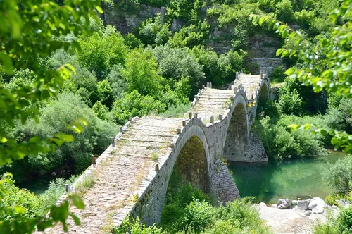
Afbeelding van Karl Egger via Pixabay
Accommodaties
Adipni Villas, Pelecas Country Club, Villa Panorea, Niki Sunrise Apartments, Isabella Country House, Ziogas Luxury Apartments, Fundana Villas, Stalakton Country Maisonettes, Spileo House en Kassiopi Mare Maisonettes
In de Buurt
- Wandelvakantie OostenrijkBergwandelen, huttentochten of meer ontspannen wandelen door een vallei of over een Alpenweide. Oostenrijk heeft volop wandelmogelijkheden. Op deze pagina enkele toppers. Kalkalpenweg Deze route…
- Wandelvakantie TurkijeTijd zonvakantie aanbidders kozen turkije ligt ver. Vandaag dag trekt bestemming middellandse zee actieve reizigers, voet mooiste plekken turkije verkennen: wandelvakantie turkije populairder. Mooi wandelen…
- Wandelvakantie KroatiëKroatië bezoekt prachtige natuur schitterende nationale parken, eeuwenoude historie, cultureel erfgoed monumenten werelderfgoedlijst unesco wilt genieten mooie excursies heerlijk zacht klimaat, busreis kroatië.
- Wandelvakantie AlbaniëBeste Reistijd Albanië